54 Sights in Zakopane, Poland (with Map and Images)
Legend
Welcome to your journey through the most beautiful sights in Zakopane, Poland! Whether you want to discover the city's historical treasures or experience its modern highlights, you'll find everything your heart desires here. Be inspired by our selection and plan your unforgettable adventure in Zakopane. Dive into the diversity of this fascinating city and discover everything it has to offer.
Sightseeing Tours in Zakopane1. Cmentarz Zasłużonych na Pęksowym Brzyzku

The Cemetery of Merit in Pęksowy Brzyzek in Zakopane – the first cemetery in Zakopane at Kościeliska Street, founded in the second half of the 19th century by the first parish priest of Zakopane, Father Józef Stolarczyk.
2. Shrine of Our Lady of Fatima

The Sanctuary of Our Lady of Fatima in Zakopane's Krzeptówki – a Roman Catholic Marian sanctuary in Poland, built as a votive offering for saving the life of Pope John Paul II after the assassination attempt of May 13, 1981. It is located at Krzeptówki Street.
Wikipedia: Sanktuarium Matki Bożej Fatimskiej w Zakopanem (PL), Website
3. Kaplica pw. Najświętszego Serca Jezusa w Jaszczurówce

The Chapel of the Sacred Heart of Jesus in Jaszczurówka – a filial church of the Roman Catholic parish in Toporowa Cyrhla – was designed by Stanisław Witkiewicz. Construction began in 1904, and the consecration was made in 1907.
Wikipedia: Kaplica Najświętszego Serca Jezusa w Jaszczurówce (PL), Website
4. Myślenickie Turnie

Myślenickie Turnie – a crest built of sedimentary rocks on the northern ridge of Kasprowy Wierch, 1354 m above sea level, in the Western Tatras. The origin of the name is unknown. Some claimed that it was a transformed name "Myśliwieckie Turnie", but this is only a guess, not based on anything.
5. Krajná Kopa / Skrajna Turnia

Skrajna Turnia – the first peak from the west in the High Tatras Ridge, located between the Liliowe Pass and the Extreme Pass. The next peak in this ridge to the east is Pośrednia Turnia, and then Świnica. The Polish-Slovak border runs through these peaks and passes. The Extreme Turnia is made of granitoids. In 1850, Ludwik Zejszner wrote about it: "... It lies in the middle of the Tatra range and is a petrographic boundary for granite.".
6. Mały Kościelec

Mały Kościelec – a multi-peak ridge that is the end of the Kościelce Ridge, which at the height of Zawratowa Turnia diverges in the northern direction from the main ridge of the High Tatras and separates the Czarna Gąsienicowa Valley from the Zielona Gąsienicowa Valley. Between Mały Kościelec and Kościelec there is the Karb Pass. Mały Kościelec has several unremarkable peaks, in the order from south to north: 1859 m, 1863 m, 1866 m, 1863 m, 1849 m, 1840 m, 1815 m, 1792 m, 1767 m.
7. Galeria Sztuki XX wieku w willi Oksza

Villa "Oksza" – a residential building in the Zakopane style, designed in the years 1894–1895 by Stanisław Witkiewicz and located in Zakopane at 25 Zamoyskiego Street. Since 2006, it has been the seat of a branch of the Dr. Tytus Chałubiński Tatra Museum, where the Gallery of 20th Century Art is located.
8. Willa Pod Jedlami

The "Pod Jedlami" Villa – a villa in the Zakopane style in Zakopane designed by Stanisław Witkiewicz. Built in 1897, investor Jan Gwalbert Pawlikowski, building structures: Zapotoczny and Obrochta.
9. Prostredná kopa / Pośrednia Turnia

Pośrednia Turnia – the second peak of the High Tatras from the west, located in the main ridge of the Tatra Mountains, between Skrajna Turnia and Świnica, from which it is separated by the Świnicka Pass. To both of these passes it descends on rocky and steep slopes. In the north-eastern direction to the Zielona Gąsienicowa Valley, it forms a short rocky ridge. Its north-western slopes descend to the Extreme Gully descending from the Extreme Pass, the south-eastern slopes to the Świnicka Kotlinka. To the south-east, to the bottom of the Walentkowa Valley, a steadily sloping slope descends, in the upper part it is rocky debris, below it is rocky and grassy, at the very bottom it is overgrown with dwarf mountain pine. The peak is made of granitoids.
10. Muzeum Jana Kasprowicza

Villa "Harenda" – the house of Jan Kasprowicz in Zakopane on Harenda, on the slopes of Gubałówka. The poet purchased it in 1923 from the English painter Winifred Cooper with the money he earned from translating Shakespeare. Currently, it houses Kasprowicz's biographical and literary museum. The name of the villa comes from the inn "Pod Arendą" located in Czarnowąsy near Opole. Later Kasprowicz changed the name by adding a highlander aspiration h. The future poet visited this inn during his school education in 1881.
11. Gubałówka

Gubałówka is a mountain in the Gubałówka Range, above the Polish town of Zakopane. The mountain is a popular tourist attraction, offering commanding views of the Tatras and Zakopane. In 1938 the Gubałówka Hill funicular connected Zakopane and the top of Gubałówka. The chair lift to Butorowy Wierch was opened in 1978.
12. Dworzec Tatrzański

Tatra Railway Station – a building located in Zakopane at 12 Krupówki Street. It served as the first Zakopane cultural center. It has never been a railway station, the railway station in Zakopane is located in a completely different part of the city.
13. Jaskinia Bystrej

Bystra Cave, formerly also Nižní Kalacká Cave – a cave located in the Western Tatras in the Bystra Valley, at the foot of Kalacká Turnia. Together with the Kalacka Cave and the Dudnica Cave, it is part of the drainage system of the Giewont massif.
14. Krokiew

Krokiew – a two-peak montane hill in the Tatra Mountains above Zakopane, located between the Bystra Valley and the Biały Valley. On its slopes, a ski jumping complex was built, which includes Wielka Krokiew and the Ski Jumping Complex of Średnia Krokiew.
15. Jaskinia Juhaska

Juhaska Cave, formerly known as Juhaska Cave – a cave, or rather a shelter, in the Strążyska Valley in the Western Tatras. It has two entrance openings located in the northern wall of Juhaska Turnia in the massif of Długi Giewont, in the Banie couloir, at a distance of about 100 m in a straight line from the Wyżnia Sucha Pass, at an altitude of 1570 m and 1586 m above sea level. The length of the cave is 23 meters, and its denivelation is 16 meters.
16. Grzybowiec

Grzybowiec – a montane hill in the Western Tatras between Mały Giewont, from which it is separated by the Bacuch Pass and Łysanki. From the south, its slopes descend to the Mała Łąka Valley, from the north to the Strążyska Valley and the Grzybowiecka Valley. It is separated from the Łysanek hill lying north of it by the Pass in Grzybowiec.
17. Boczań

Boczań – a hill in the montane part of the Western Tatras, above the Jaworzynka Valley. It is the western branch of the High Road. It is separated from Skupniowy Upłaz by Skupniów Przechód and Skupniów Żleb. Both the top and the slopes are covered with forest.
18. Kościół pw. św. Jana Apostoła i Ewangelisty

The Church of St. John the Apostle and Evangelist in Harenda – a wooden church built in the years 1710–1720 in Zakrzów near Kalwaria Zebrzydowska, moved in 1947 to Zakopane. It is surrounded by Saturdays. The interior is decorated with guild paintings, renovated by Władysław Jarocki. Next to the church there is a mausoleum and the villa "Harenda". The church is located on the Małopolska Wooden Architecture Route.
Wikipedia: Kościół św. Jana Apostoła i Ewangelisty na Harendzie (PL)
19. Jaskinia Magurska

Magura Cave – a cave located in the Western Tatras on the western slopes of the Jaworzynka Valley. It has two entrance openings located in a gully descending from the Jaworzyńska Pass to the Żleb pod Czerwieńca at an altitude of 1460 and 1475 meters above sea level. The length of the cave is 1285 (1200) meters, and its denivelation is 59 meters. It is known for the bones of a cave lion, a cave hyena, and above all a cave bear.
20. Jatki

Jatki – a group of crags in the north-eastern ridge of Łysanka, between the peak of Łysanki and Samkowy Zwornik. The highest of them is about 1380 m above sea level. They rise in the ridge of Łysanki above the Grzybowiecka Valley and the Valley behind the Gate. There are several small caves in them, m.in. the Chamber in Jatki, the Niche in Jatki, the Tunnel in Jatki, the Fireplace in Jatki, the Cave in Jatki and the Leaky Niche in Jatki.
21. Ogród Botaniczny im. Mariana Raciborskiego

Marian Raciborski Mountain Botanical Garden of the Institute of Nature Conservation of the Polish Academy of Sciences in Zakopane – the botanical garden in Zakopane is an integral part of the Tatra Field Station of the Institute of Nature Conservation of the Polish Academy of Sciences. It is the smallest botanical garden in Poland.
22. Suchy Wierch

Suchy Wierch – a montane peak in the Polish Western Tatras, rising in the ridge separating the Strążyska Valley in the west from the Biały Valley in the east. In this ridge it is located between Nižní Suchá sedloľa (1508 m) and Červená sedlo (1301 m). In its eastern slopes there are no ridges or perches, while in the western direction from its top the Horse Ridge separates the Jeleni Żleb from Sarni Żleb.
23. Centrum Edukacji Przyrodniczej Tatrzańskiego Parku Narodowego

The Nature Education Center of the Tatra National Park, formerly the Natural History Museum of the Tatra National Park in Zakopane – an institution of the Tatra National Park, which operated under the name of the Natural History Museum of the Tatra National Park in the years 1984–2004.
Wikipedia: Centrum Edukacji Przyrodniczej Tatrzańskiego Parku Narodowego (PL)
24. Jaskinia Kalacka

Kalacka Cave – a cave located in the Bystra Valley in the Western Tatras. The entrance to it is located on the eastern slope of Kalacka Turnia descending to the Kalatówka clearing, above the Bystra Spring, slightly above the marked tourist trail to the Kondratowa Valley, at an altitude of 1230 meters above sea level. The length of the cave is 405 meters, and its denivelation is 19 meters.
25. Turnia nad Białem

Crag on the Biały River – a crag in the ridge of the Long Giewont in the Polish Western Tatras. It is located in the eastern part of this ridge, steeply descending to Kalacka Kopa, between Wrótki and Wyżne Wrótki. The latter pass is located just on the west side of Turnia nad Białem, while a grassy and rocky ridge about 450 m long descends to Wrótka.
26. Jaskinia Kasprowa Średnia

Kasprowa Średnia Cave – a cave in the Stare Szałasiska valley in the Western Tatras. The entrance to it is located in Zawracik Kasprowy at an altitude of 1407 meters above sea level. The length of the cave is 150 meters, and its denivelation is 53 meters. Above it is the Kasprowa Wyżnia Cave.
27. Jaskinia Kasprowa Wyżnia
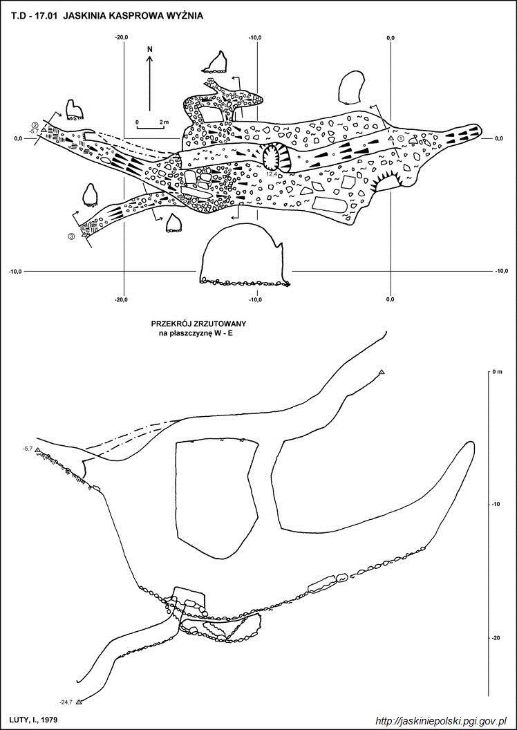
Kasprowa Wyżnia Cave – a cave in the Stare Szałasiska valley in the Western Tatras. It has three entrance openings in Zawracik Kasprowy above the Kasprowa Medium Cave at an altitude of 1438, 1463 and 1467 meters above sea level. The length of the cave is 100 meters, and its height difference is 24.7 meters.
28. Wysokie

Wysokie – a montane, forested crest in the north-eastern ridge of Kasprowy Wierch in the Polish Western Tatras. It rises in the ridge separating the lower part of Jaworzynka from the Olczyska Valley, between Skupniowy Upłaz, from which it is separated by Skupniowy Przechod, and the forested Nieborak, from which it is separated by a shallow pass. Wysokie is a keystone – the Boczań ridge departs from it in the western direction. Between these two hills there is a forested, shallow depression with water intakes for Zakopane.
29. Dudnica

Dudnica – a cave in the Bystra Valley in the Western Tatras. It has two entrance openings, located close to each other, at the foot of Kalacka Turnia at an altitude of 1181 meters above sea level, near the mouth of the Bystra Cave. The length of the cave is 185 meters, and the denivelation is 12 meters.
30. Samkowy Zwornik

Samkowy Zvornik – a peak in the north-eastern ridge of Łysanki in the Polish Western Tatras. On some maps it is erroneously marked as Kiernia crag, in fact Kiernia is located elsewhere. Samkowy Zkeynik is a domed hill overgrown with dwarf pine and forest, only on the eastern side it is undercut by a small wall. From its top, as Władysław Cywiński writes: The view of the surroundings of the Strążyska Valley – sensational. The name Samkowy Zwornik comes from the Podhale surname or nickname Samek. It is the keystone; the ridge of Łysanki splits into two ridges: the north-eastern one separating the Strążyska Valley from the Suchy Żleb. There is the Samkowe Siodło pass and the top of Samkowa Czuba, the north-western Samkowy Ridge, separating the Suchy Żleb from the Valley behind the Goal.
31. Nieborak

Nieborak – a hump in the north-eastern ridge of Kasprowy Wierch in the Polish Western Tatras, between Nosalowa Przełęcza and Wysokie, from which it is separated by a pass cut only about 3 m. The western slopes of Nieborak fall to the Bystra Valley, the eastern slopes to the Olczyska Valley. It is completely forested. In the northern direction, a depression descends from under its top, turning into a gully descending in the north-western direction to the Bystra Valley. A stream flowing down it flows under Nosal into an artificial reservoir in front of the dam on Bystra.
32. Kalacka Turnia
Kalacka Turnia – a crag rising above the Kalatówki clearing in the Polish Tatra Mountains. It is located at the end of the eastern ridge of the Long Giewont. On Kalacka Kopa this ridge splits into two branches; Kalacka Turnia is located in the orographically right. Its south-western slopes descend to the Bystra Valley, the north-eastern slopes to the Kalacký Riverbed. The slopes are now completely forested, only the very top is rocky, similar to the ruins of a castle. For this reason, in the first half of the nineteenth century, it was called the "Zakopane Castle". It is built of limestone rocks. The limestone substrate causes karst phenomena to occur here. At the south-western foot of Kalacka Turnia there is a large Bystra Spring, and in the slopes there are caves: Mokra Koleba, Fascinating Nyża, Kalacki Tunnel, Dudnica, Kalacka Cave, Bystra Cave, Hole behind the Boulders, Kozi Korytarz.
33. Czarna Turnia

Czarna Turnia – a wall in the northern slopes of the Grzybowiecka Valley in the Polish Western Tatras. It rises in the south-eastern ridge of Łysanki, below their highest peak. It is about 25 m high, rises in the forest and is made of carbonate rocks: dolomites and limestones
34. Liliowa Kopka

Liliowa Kopka – a not very prominent peak in the Western Tatras, between the Liliowe Pass and the Wyżnie Liliowe Pass, separating it from the Beskid Mountains. It is located in the main ridge of the Western Tatras. The names Liliowa Kopka and Wyżnie Liliowe were introduced by Władysław Cywiński in his guidebook Tatry.
35. Zawracik Kasprowy

Zawratik Kasprowy – a ridge branching off from Rówienki in the Polish Western Tatras and is an extension of Zawrat Kasprowy. From Rówienki it descends west-north-west, ending at Kasprowa Polana. On the eastern side, its slopes are steep, overgrown with forest cliffs, while on the west side, to Stare Szałasiska, it descends with a rock wall up to 100 m high. one of the scree runs westwards, separating Zawracik and Zawrat Kasprowy from each other, the other forested slopes in the north-western direction to Kasprowa Polana.
36. Juhaska Turnia
Juhaska Turnia – a crag in the ridge of Długi Giewont in the Polish Western Tatras, located between Juhaska Przehyba and Szczerbinka. On the southern side, a several-dozen-meter-high wall descends to the Great Upłaz in the Kondratowa Valley, while in the northern direction the outstanding Juhaski Filar descends from it to the Banie couloir in the Strążyska Valley.
37. Kondracka Kopka

Kondracka Kopka – a mound in the northern ridge of Kopa Kondracka, located between the Kondracka Pass and the Wyżnia Kondracka Pass, above which it rises only a few meters. It is mostly overgrown with dwarf pine, grassy and scree in places. Its eastern slopes descend to Hell in the Kondratowa Valley, the western slopes to Wyżni in the Mała Łąki Valley. A short perch descends to the latter valley from Kondracka Kopka, separating two gullies descending from the slopes below the Kondracka Pass and Wyżnia Kondracka. These gullies below the perch connect with each other, creating the Głazisty Żleb. The opposite slopes between Kondracka Kopka and Giewont are cut into the Kurski Żleb.
38. Mokra Koleba
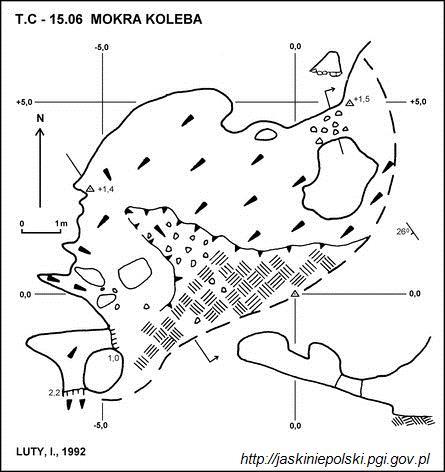
Mokra Koleba – a cave, or rather a shelter, in the Kondratowa Valley in the Western Tatras. The entrance to it is located on the southern slope of Kalacka Turnia, at an altitude of 1285 meters above sea level. The length of the cave is 11 meters, and its denivelation is 2.5 meters.
39. Pośredni Wierszyk
Pośredni Wierszyk – a ridge separating the Valley behind the Gate from the Mały Żlebek valley in the Polish Western Tatras. It departs in the northern direction from the north-western ridge of Łysanki and descends to the Road under the Reglami. On its eastern slopes there are numerous rocks and crags called Jasiowe Tursie. It is completely covered with forest and there are no tourist trails leading through it. It is located in the strict protection area of Regle Zakopane.
40. Juhaska Kopa
Juhaska Kopa – a small bulge in the ridge of the Long Giewont in the Polish Western Tatras between Juhaska Przehyba and Wyżni Wrótki. The northern slopes descend with a wall both to the Sucha Valley and to the Banie couloir in the upper part of the Strążyska Valley. The southern slopes descend to the Kondratowa Valley.
41. Suchy Wierch Olczyski

Suchy Wierch Olczyski – a ridge rising above the south-eastern edge of Olczyska Polana in the Polish Western Tatras. It divides the upper part of the Olczyska Valley into two branches: eastern and western. It departs from Queen Ridge in a northwesterly direction. Initially, it is only a barely noticeable protuberance, but the further away from the Queen Ridge, the more it rises above its surroundings, and its slopes are steeper and steeper. It is built of limestone rocks, but rarely you can also find granite boulders dragged by the glacier from the High Tatras. At its highest point, it reaches a height of 1225 m above sea level. It is completely covered with forest, but in its slopes, especially the left ones, there are bare rocks. There are also a few clumps of dwarf mountain pine of natural origin, below its normal vertical range.
42. Skrajna Giewoncka Baszta

Extreme Giewoncka Baszta – one of the crags in Mały Giewont in the Western Tatras. It is located at its northern end, between the Bacuch Pass and the Pass over the Hole. The western slopes descend to the Mała Łąki Valley, the northern slopes to the Warzecha Gully, the eastern to the Kirkor Gully. The height of Mały Giewont, given on many maps, most likely refers to this crag, because it seems to be the highest from Zakopane, and for Austrian cartographers it was also the most easily accessible.
43. Zadnia Giewoncka Baszta

Zadnia Giewoncka Baszta – one of the crags in Mały Giewont in the Western Tatras. Like the entire massif of Mały Giewont, it is built of sedimentary rocks – limestone and dolomite. It is located between Zadni Giewoncki Karbik and Skrajny Giewoncki Karbik. The eastern walls descend to the Kirkor Gully, the south-western to the Mała Łąki Valley near the Siodło Pass.
44. Giewoncki Chłopek

Giewoncki Chłopek – crag in Mały Giewont in the Western Tatras. It is located between the Giewoncka Pass and the Zadni Giewoncka Baszta. In the ridge between the Giewoncka Pass and Giewoncki Chłopek there are several more small turnstiles, while it is separated from the Zadnia Giewoncka Tower by the Zadni Giewoncki Karbik. It descends to it with an almost vertical fault of about 10 m. The passage through this fault was rated as III on the UIAA (Tatra) scale of difficulty. Giewoncki Chłopek can be easily walked around from the south, while to the north side it descends to the Kirkor Gully with a wall.
45. Kogutki

Roosters – two small crags in the ridge bordering the Gully under the Roosters in the Polish Western Tatras from the east. A slightly higher northern crag rises to a height of 1009 m above sea level.
46. Jastrzębia Turnia

Jastrzębia Turnia – a rock in the northern slopes of the Krokiew massif in the Polish Western Tatras. It is located in the ridge separating the Valley on the Capkami River from the Gully under the Roosters. It is the same ridge on which the ski jumps were built: Wielka Krokiew and Średnia Krokiew. Jastrzębia Turnia rises above these hills, to a height of about 1090 m above sea level. It is made of carbonate rocks and was used by rock climbers. Its highest wall is 11 m high, 8 of which are difficult. There are 4 climbing routes with a maximum difficulty of VIII degree on the UIAA (Tatra) difficulty scale.
47. Kiernia
Fire - Turnia in the Łysanek massif in the Polish Western Tatras. It is located in their north-east ridge, below the jat, on a slope falling into the Strążyska Valley. On some maps it is incorrectly placed in the place of the male jumper. Below are a few turns, it is not known for sure which of them is the name of the direction, on different maps it is marked in different places. Władysław Cywiński believes that "in the past, what was very conspicuous", so the name fits the name to the mossy turnian located on the slope a few hundred meters below the highest Turnia Jatek, more or less in the line of inheritance to the Strążyska Valley.
48. Szara Turnia

Szara Turnia – one of the crags in Mały Giewont in the Western Tatras. It is the most prominent of all crags of Mały Giewont and is well visible from Zakopane, especially in the morning. It is located on the north-eastern ridge of the Extreme Giewoncka Baszta, separated from its top by the Grey Pass. It has two peaks, the southern one is slightly higher. From the shallow and grassy saddle between these peaks, the jam falls. It is steep and stretches along the entire length of the wall. The northern walls of Szara Turnia descend to Szary Żleb. In the upper part of the wall of the northern peak of Szara Turnia there is a partly grassy, partly slab west. Szara Turnia, like the entire massif of Mały Giewont, is built of sedimentary rocks – limestone and dolomite.
49. Biała Giewoncka Baszta
Biała Giewoncka Baszta – one of the crags in Mały Giewont in the Western Tatras. Like the entire massif of Mały Giewont, it is built of sedimentary rocks – limestone and dolomite. It is located between the Pass over the Hole and the Giewoncki Pass. The north-eastern walls descend to the Kirkor Gully, the south-western to the Mała Łąki Valley; from this side, they are covered by two arms of the Gully with the Threshold approaching the passes on both sides of the crag.
50. Mała Krokiew

Mała Krokiew – the lower of the two peaks of the Krokiew massif in the montane part of the Polish Western Tatras. From the main peak of 1378 m located to the north of it, Mała Krokiew is separated by a shallow and wide Siwarowy Siodło, while in the south it borders with the White Ridge with the two-saddle Biały Pass. The nearest hill to Mała Krokiew is Biała Czubka, separated from it by the Niżnia Przełęka Białego. In the longer term, Mała Krokiew in the south is adjacent to Kalacka Kopa in the Giewont massif.
51. Czuba nad Karbem

Czuba nad Karbem – a rocky crest in the Kościelce Ridge in the High Tatras. It is located between Kościelec and the Karb Pass, much closer to the latter. The south-western slopes descend steeply to the Long Pond, the north-eastern slopes descend with a wall to the Black Pond. From the eastern side, on the sides of Czuba nad Karbem, two large gullies descend into the Black Pond: the nameless gully from the Karb Pass, and on the other side the Zaruski Gully.
52. Wysoka Giewoncka Baszta
High Giewoncka Baszta – one of the crags in Mały Giewont in the Western Tatras. Like the entire massif of Mały Giewont, it is built of sedimentary rocks – limestone and dolomite. It is located between the Extreme Giewoncki Karbik and the Giewoncki Pass. The eastern walls descend to the Kirkor Gully, while to the west to the Mała Łąka Valley there is a short ridge ending with the Saddle Crag. From the side of Saddle Turnia, this ridge is quite clear, rounded and grassy, above the Saddle it flattens out and grows into the walls of the Zadnia Giewoncka Tower in a hardly distinguishable place. In addition, one more rocky perch descends to the Valley of the Small Meadow from Wysoka Giewoncka Turnia, which separates two gullies. Looking from the bottom, on the left side of this perch there is the Gully with the Threshold, on the right the Gully of the Sleeping Knights.
53. Zameczki

Zameczki – a group of crags and rocks in the Biały Valley in the Polish Western Tatras. They are located in an unnamed ridge about 1.5 km long, which branches off from the ridge of Długi Giewont about 200 m west of Wrótki and descends northwards to the Biały Valley, dividing its upper part into two branches. The castles are located in this ridge above the Path over the Reglami, the ridge continues down the Biały Valley.
54. Sucha Czubka
Sucha Czubka – an unremarkable montane peak in the ridge separating the Biały Valley from the Strążyska Valley in the Western Tatras. It is located in the upper, southern part of this ridge, between Wyżnia Sucha Przełęcza and Niżnia Sucha Przełęcza. On the eastern side, its slopes descend to the Sucha Valley. On the western side, to Wielka Równia in the upper part of the Strążyska Valley, the wooded and rocky Deer Ridge descends from it.
Share
How likely are you to recommend us?
Disclaimer Please be aware of your surroundings and do not enter private property. We are not liable for any damages that occur during the tours.