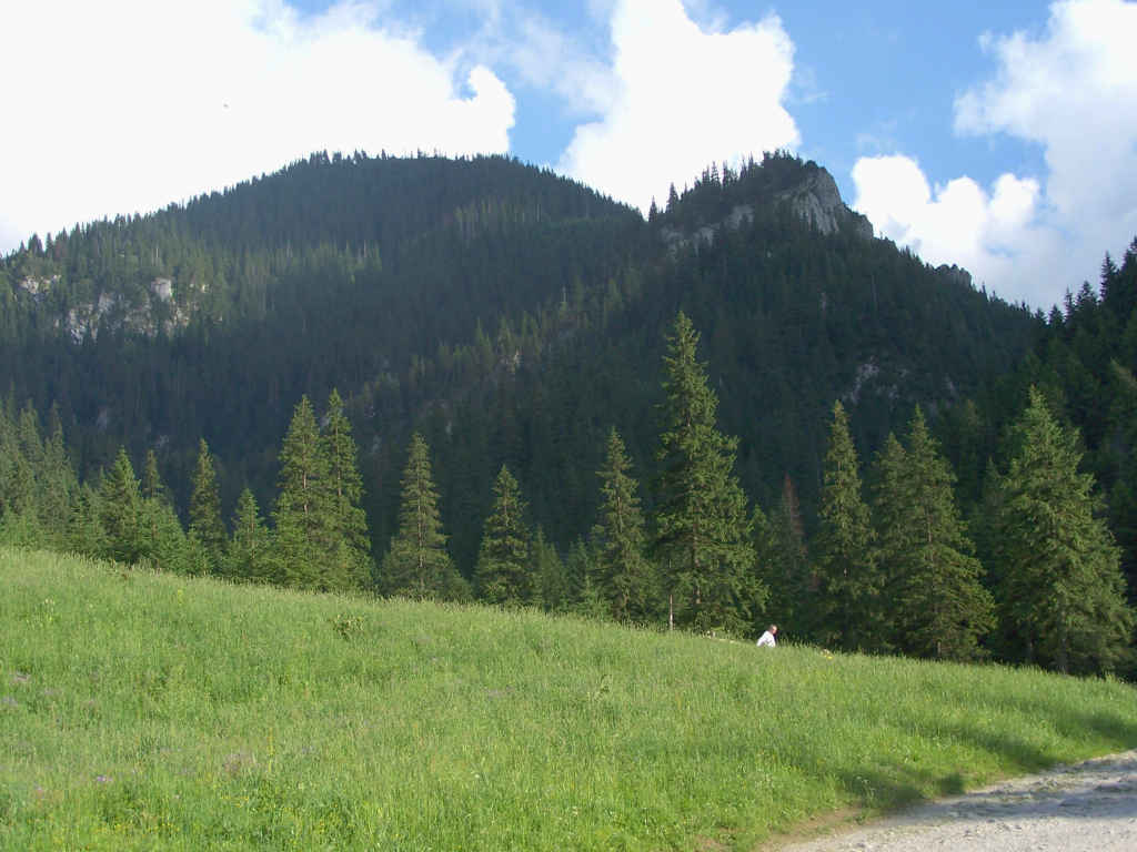
63 Sights in Kościelisko, Poland (with Map and Images)
Legend
Welcome to your journey through the most beautiful sights in Kościelisko, Poland! Whether you want to discover the city's historical treasures or experience its modern highlights, you'll find everything your heart desires here. Be inspired by our selection and plan your unforgettable adventure in Kościelisko. Dive into the diversity of this fascinating city and discover everything it has to offer.
Sightseeing Tours in Kościelisko1. Jaskinia Mroźna wejście
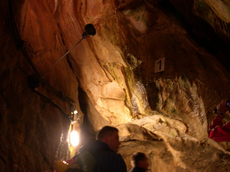
The Mrozna Cave is a cave on the eastern slope of the Kościeliska Valley in the Tatra Mountains, in the Organ Massif, 120 m above the valley floor. The entrance to the cave is located at an altitude of 1100 m above sea level, and the exit opening at an altitude of 1112 m above sea level. The total length of the cave is 773 m.
2. Jaskinia Czarna

The Black Cave is a cave in the Western Tatras in the Organ Massif in the Kościeliska Valley. It is one of the largest and most extensive caves in the Tatra Mountains. It ranks sixth in terms of length and ninth in terms of denivelation in Poland. It has four entrance openings: two at the foot of Czarna Turnia above Polana Pisana at an altitude of 1326 and 1294 meters above sea level, the third one on the slope of the Żleb pod Wysranki, above Hala pod Upłazem, at an altitude of 1404 meters above sea level, and the fourth located a few meters above the main opening at an altitude of 1330 meters above sea level. Some parts of the cave are poorly explored and documented. In June 2016, the length of the discovered corridors was 7247 meters, and the height difference was 303.5 meters.
3. Blyšť / Błyszcz

Błyszcz – a poorly demarcated end of the northern ridge of Bystra, the highest peak in the Western Tatras. From the geographical point of view, Błyszcz is not a peak, because it has zero minimum relative denivelation, i.e. there is no depression of the ridge between it and Bystra. It has a height of 2159 m above sea level and is built of granite and gneiss. It rises above the valleys: Pysznianska, Kamienista and Gaborowa.
4. Upłazkowa Turnia

Uplazkowa Turnia - Turnia in the eastern slopes of the Kościeliska Valley in the Western Tatras. It is located in the south-western ridge departing from Równia on the inn, which through the Uphesive Turnia, Saturn and the Town Hall falls to the bottom of the Kościeliska Valley, creates the right border of the Kraków gorge over a significant length and separates it from the writing gully. Up arrears over the Karczma is separated by a Up arrears, from Saturn, a pass from Saturn. Uplaskowa Turnia is made of carbonate rocks. Watched from above, it is an inconspicuous, not much up to the grassy ridge of the Uploaded Skał group, but to the Kraków gorge it partly falls with walls, and partly a very steep slope. The relative height of the top over the bottom of the Krakow Gorge reaches 350 m. There are many caves here, including Cave with concretions of Niżnia, a hole on the West, hole under the wanta, triangular shelter, shelter in Up arrival Turnia, Up arrival, Up arrears, wet gap, cracked gap, gawra, small gawra, cave at Percia, Skoruszowa cave, cave nad percia, arkada , Shelter at the arcada, cave over the arcade, hole under the arcade, hidden shelter, lamb cave, tunnel under the Up arrival passage, mirror corridor.
5. Butorowy Wierch

Butorowy Wierch, once called Butorowski Wierch – a hill in the Gubałowskie Foothills, between Palenica Kościeliska and Gubałówka. It is located on the Kościelisko near Zakopane. Its northern slope is forested. It is connected with Gubałówka by a scenic section of the Papal Trail.
6. Jaskinia Obłazkowa

Obłazkowa Cave – a cave in the Kościeliska Valley in the Western Tatras. Together with the Mylna Cave and the Raptawicka Cave, it is part of the Pawlikowski Caves system. It is located at the foot of a limestone crag, called Raptawicka Turnia, on the western side of the valley, at an altitude of 1096 m above sea level, 130 m above the bed of the Kościeliski Stream. The path leading to it is located 4.4 km from Kir, 100 m above Skała Pisana. It is open to tourists, you can visit it on your own, without a guide, all year round. The temperature inside the cave is low.
7. Jaskinia Raptawicka

Raptawicka Cave – a cave in the Kościeliska Valley in the Tatra Mountains. Together with the Mylna Cave and the Obłazkowa Cave, it forms the Pawlikowski Cave system. The path leading to it is 4.4 km from Kiry, 100 m above Skała Pisana, in Raptawicka Turnia, on the western side of the valley. The cave opening, located approx. 180 m above the bed of the Kościeliski Stream, is visible from the road leading along the bottom of the valley. The cave can be visited on your own, without a guide. The temperature inside is low.
8. Jaskinia Wodna pod Pisaną

Water Cave under the written, also called the written cave - a cave located in the Kościeliska Valley in the Western Tatras. The cave has three holes, the total length is 450 m, it is located at an altitude of 1023–1028 m a.s.l. The most famous cave outlet is located 4.3 km from Kir, above the written clearing, under a lime written rock. In this place, water flows out of the cave, which with underground troughs and crevices from Kościeliski Potok, as well as from the Kraków gorge. Entering the cave with this hole, it wanders in the cold water. Strong current makes it difficult to move. However, a large part of the cave is devoid of water, which is why the cave usually enters the other two, easily accessible holes. One is located a few meters south of the exhaust hole with water, almost on the road leading the Kościeliska Valley. In the 1990s, it was damaged during road renovation. The next one is several dozen meters south along the road right at Kościeliski Potok. Until the mid -1990s, when the slope was hit, partly covering the hole, it was the largest and most visited entrance to the cave.
9. Kończysta Turnia

Kończysta Turnia – a crag in the north-western ridge of Małołączniak in the Polish Tatra Mountains. It rises above the forest in the northern part of the Miętusia Valley, at the point where it joins the Kościeliska Valley. It is separated from Czerwony Gronik by the Spalone Siodło pass. It has two peaks, the western one is slightly higher. The peaks are connected by a narrow ridge, which descends on both sides with walls and cliffs. To the south-west, the crag descends with a wall about 80 m high, its upper part is the steepest. To the north and west, it descends with lower, but steeper walls. In the walls connecting it with the Burnt Saddle there are two smaller turnstiles. However, the entire summit block of Kończysta Turnia can be easily circled about 40 m below its peaks.
10. Jaskinia Wodna pod Raptawicką

The Water Cave under Raptawicka – a cave in the Kościeliska Valley in the Western Tatras, located at the foot of the limestone massif of Raptawicka Turnia. It is located 4.4 km from Kir, on the western side of the valley, about 100 m north of the Pisana Rock. It has five entrance openings located right next to the Kościeliski Stream, exactly below the path leading to the Pawlikowski Caves at altitudes of 1027 and 1032 m above sea level. The length of the cave is 170 meters, and its height difference is 5 meters.
11. Jaskinia Zimna

Zimna Cave – a cave located in the Western Tatras on the eastern slopes of the Kościeliska Valley, near the Mrozna Cave. It has two entrance openings located in the rocks of the Organ: the lower (main) one at an altitude of 1120 meters above sea level and the upper one at an altitude of 1260 meters above sea level. The length of the cave is 5420 meters, and the denivelation is 176 meters. It is currently ranked 12th in terms of depth and 8th in terms of length in the Polish Tatras. About 60 meters below it is the Stalactite Cave.
12. Brama Kantaka

Niżnia Kościeliska Gate also known as the Kantaka Gate – a narrow rock gate, with almost vertical rocks, carved by the Kościeliski Potok in very hard Jurassic limestone in the Kościeliska Valley in the Western Tatras. It is about 10 m wide, about 30 m long, and its bottom is at a height of 935 m. The limestone rocks that form it are overgrown, m.in, daphne, black dry forest and rock grasslands with mountain daisy, saxifrage staphylococcus and ferns.
13. Brama Kraszewskiego

The Intermediate Kościeliska Gate, also known as the Kraszewski Gate, is a rock gorge in the Kościeliska Valley in the Western Tatras, about 0.5 km long. It is located 2.5 km from the hamlet of Kiry, above the Stare Kościeliska clearing. Its almost vertical walls, built of light limestone, reach a height of up to 100 m. On the eastern side, there is the Okręt crag. They are covered with spruce upper-montane forest, largely primary, untouched by man. Trees growing on the rocks sometimes take on peculiar forms. The Kościeliski Stream flows at the bottom of the gorge, next to it there is a road and a tourist route. On the left, the black tourist trail to the Mrozna Cave branches, and 50 m higher to the right, the blue trail to Stoly and Hala na Stolach.
14. Zbójnicka Turnia
Zbójnicka Turnia – a crag on the western slopes of Gubalec forming the eastern wall of the Wyżnia Kościeliska Gate in the Kościeliska Valley in the Western Tatras. It is located about 800 m south of Polana Pisana, above Skała Pisana. It is separated from the top of Gubalec by a wide pass called Wyżni Zbójnicki Przechod. The name of the crag is related to the robbers' past of the Kościeliska Valley. According to the highlanders, its caves were inhabited by robbers and the treasures they collected are located there. These caves were searched many times by treasure hunters in the past centuries, as evidenced by the signs they carved on the walls.
15. Skała Pisana

Skała Pisana – a several-meter-high vertical, flat limestone rock located in the Kościeliska Valley in the Western Tatras. It is located 4.3 km from Kiry, above Polana Pisana, in the rocky gorge of the Kościeliski Stream, called Wyżnia Kościeliska Brama. It is located on the eastern side of the valley, the western side of the rock gorge is formed by the cliffs of Raptawicka Turnia. The entire rock is covered with almost invisible autographs of several generations of tourists from years ago, among which there are also signatures of famous people, e.g. the painter Henryk Siemiradzki. The rock is located right next to the wooden bridge over the Kościeliski Stream.
16. Zawiesista Turnia

Zawista Turnia – a crag rising in the northern slopes of the Miętusia Valley in the Western Tatras. It is located in the southern ridge of Czerwony Gronik, separated from it by the saddle behind Zawista. It is built of limestone rocks.
17. Sowa

Sowa – a crag in the Kościeliska Valley in the Western Tatras. It is located on the western side of this valley, almost opposite the descent path from the Mrozna Cave, below the Stołowy massif. Its steep white walls rise above the forest right next to the Kościeliski Stream to an altitude of about 1050 m above sea level. It is also perfectly visible from the Pisana Glade, located 600 m to the south. It is built of limestone and has a characteristic shape, which was associated with the creators of the name with an owl. Above Sowa, at a distance of 200 m from it, there is a much higher Kazalnica.
18. Sivá veža / Siwy Zwornik

Siwy Zwornik – a peak in the Western Tatras, located in the main ridge of the Western Tatras. The Polish-Slovak border runs through it. It is built of crystalline rocks. To the west of it there is the Gaborowa Pass and the lofty pyramid of Starorobociański Wierch, and to the south-east the Liliowy Karb Pass and the low, jagged ridge of Liliowy Turnia. Siwy Zwornik rises above three valleys: Starorobociańska, Pyszniańska and Gaborowa. From the north and west sides, its slopes are rocky and quite steeply undercut. The remaining slopes are overgrown with low grassland with rushes with reddening shoots.
19. Klin / Starorobociański Wierch

Klin is a peak in the Western Tatras, on the border between Slovakia and Poland. Its summit is at 2,176 metres (7,139 ft) AMSL. It is the highest peak in Polish Western Tatras. The foreground is a classic split ridge or doppelgrat, spreading under tension due to deep erosion in the valleys either side. The finest example in the Tatra is between Kamienista and Smreczynski Wierch nearby.
20. Jaskinia Naciekowa

The Dripstone Cave is a cave on the eastern slopes of the Kościeliska Valley in the Western Tatras. It is located in the dolomite-limestone massif of the Organ, about 60 m above the Cold Cave, near Zbójnicka Nyża, the Cave under Ostrewka and the Bloody Nose Cave, next to the Shelter at Naleighowa and the Corridor to Nalemikowa. It is a horizontally developed cave with three entrances located at altitudes of 1188 m, 1199 m, 1180 m above sea level. Its length is 1210 meters, and the denivelation is 97 meters.
21. Saturn

Saturn – a crag in the Kościeliska Valley in the Western Tatras. It is located in the north-western ridge of Upłazkowa Turnia, which separates the Pisanrski Gully from the Kraków Gorge. On the south-eastern side of Saturn there is the Pass behind Saturn, the north-western slopes of Saturn fall to the main course of the Kościeliska Valley, and in the south-western direction there is the Town Hall crag, separated from Saturn by the Pass behind the Town Hall.
22. Awen w Ratuszu

Awen in the Town Hall – a cave in the Valley of the Small Meadow in the Polish Western Tatras. The entrance to it is located in the Red Ridge of Małołączniak, on Czerwony Upłaza, opposite the top of Wielka Turnia, at an altitude of 1867 m. The length of the cave is 22 meters, and its denivelation is 11 meters.
23. Ratusz
Town Hall - Turnia in the Kościeliska Valley in the Western Tatras. Together with Turnia near her, Saturn is perfectly visible from the written clearing. The name was given by the former tourists. Built of carbonate rocks, the town hall smaller than Saturn is 1296 m a.s.l. It is located in the orographically right slopes of the Kraków gorge. From Saturn it is separated by a switch behind the town hall. Only from this switch can you go out on it without much difficulty - vertical walls fall on all other pages. There are several climbing roads in them. The pillar with a height of about 170 m high is particularly impressive. The lower part of the pillar and the 40-meter height of the shelf for the first time were Jerzy Łabęcki and Ryszard Malczyk in April 1970. The first passage of the upper part: Jerzy Farat and Ryszard Malczyk on April 12, 1981. This road, named by them "from here to eternity", contains A large accumulation of difficulties with a degree VI+.
24. Jaskinia Psia

Psia Cave – the largest cave on the slopes of Gubalec falling into the Kraków Gorge in the Kościeliska Valley in the Western Tatras. The entrance to it is located at an altitude of 1410 meters above sea level, 180 m above the bottom of the gorge. The length of the corridors is 1076 meters, the height difference is 62 meters.
25. Arkada

Arkada – a cave, or rather a shelter, in the Kościeliska Valley in the Western Tatras. It has two entrance openings located on the eastern slope of the Kraków Gorge, on the slope descending from the Upłazkowa Turnia, in the same couloir as the Hole under the Arcade, the Cave above the Arcade and the Shelter at the Arcade, at an altitude of 1194 and 1201 meters above sea level. The length of the cave is 8 meters, and its denivelation is 7 meters.
26. Chuda Turnia

Chuda Turnia – a small lonely crag in the Western Tatras, located on the long, north-western ridge of Ciemniak, separating the Kościeliska Valley from its branch – the Miętusia Valley. It is located just above Chuda Przełączka. It rises to a height of 1858 m above sea level, so only 8 meters above the surrounding terrain. In the north-western direction, below Chuda Turnia, there is the Pass at Kopa, separating it from Upłaziańska Kopa. The grassy, north-eastern slopes from Chuda Turnia descend to the Twarda Gallery in the Miętusia Valley. The south-western slopes, on the other hand, descend to Zadni Kamienne. They are made of slate and there is a shallow gully in them. It is a substrate that is not conducive to vegetation and these slopes are poor in vegetation.
27. Mały Regiel

Mały Regiel – a montane hill between the lower part of the Kościeliska Valley and Stanikowy Żleb. It is the end of the north-western ridge of Małołączniak. From the north, its slopes fall to the Kościeliski Trench, and at their foot runs the Road under the Reglami, from the west to the lower part of the Kościeliska Valley, from its outlet to the Wyżnia Kira Miętusia clearing. From these slopes, two small, unnamed gullies fall into the clearing. On the northern edge of the clearing, on the slopes of the Little Regel, there are steeply undercut rocks forming the eastern gate of the Lower Kościeliska Gate. From the eastern side, the slopes fall quite steeply to the lower part of the Stanikowy Żleb. From the south, the Niżnie Stanikowe Siodło pass separates Mały Regiel from the ridge of Czerwony Gronik.
28. Jarcowa Skałka

Jarcowa Skałka – a small, approx. 3 m high rock outcrop in the Kościeliska Valley in the Western Tatras. It is located at the mouth of the valley in Kiry, right next to the forest, on the eastern side of the road running through the valley, opposite the "Harnaś" restaurant. The name was given to it by the highlanders from the numerous convex grains found on its surface, resembling cereal seeds. In fact, these grains are the so-called numulites – Tertiary, Eocene fossils, a testimony to the geological past of the Kościeliska Valley. Currently, they are hardly visible, the surface of the stone has been significantly weathered.
29. Niska Turnia

Niska Turnia – one of the crags in the upper part of the Kraków Gorge in the Kościeliska Valley in the Western Tatras. It is located in the ridge separating two glacial cirques Krakow Gorge: Zadnie Kamienne and Przednie Kamienne. This ridge begins with the south-western perch of Upłaziańska Kopa, which descends through the Wysokie Siodło, Wysoka Turnia, Niski Siodło and Niska Turnia pass to the Kraków Gorge.
30. Niedźwiedź

Niedźwiedź – a hill in the Tomanowy Ridge separating the upper part of the Kraków Gorge from the Tomanowa Valley in the Polish Western Tatras. It is located in this ridge between Tomanowy Przechod and Wolarski Przechod. The southern slopes descending to the Tomanowa Valley are forested, the ridge is partly rocky, partly overgrown with dwarf pine. The northern slopes, on the other hand, descending to the Kraków Gorge, are covered with forest only at the very bottom. Most of the northern slopes are rocky or overgrown with dwarf pine. There are two groups of rocks in them; one about 20 m below the ridge, the other above the middle part.
31. Baszta

Baszta – a crag in the orographically left slopes of the Kraków Gorge. It is the end of the north-eastern, forested perch of Gubalec. The top of the Tower rises to a height of about 1320 m above sea level and is separated from the Gubalec perch by a shallow Saddle behind the Tower
32. Palenica Kościeliska

Palenica Kościeliska – the highest peak of the Gubałowskie Foothills. It is located in the western part of this range, between Mietłówka and Butorowy Wierch. It is built of a slightly dislocated Carpathian flysch falling from south to north.
33. Dudzia Dziura

Dudzia Dziura – a cave in the Kościeliska Valley in the Western Tatras. The entrance to it is located in the Kraków Gorge, on the slope of Żar below Wielka Turnia, at an altitude of 1201 meters above sea level. The cave is 23 meters long and its height difference is 6 meters.
34. Szczelina w Krzesanicy

Szczelina w Krzesanica I – one of the three caves of the same name located in the Western Tatras near the ridge of Krzesanica above its northern wall descending to the Mulowa Valley. It has three entrance openings located at altitudes of 2091, 2092 and 2098 meters above sea level. The length of the cave is 63 meters, and its height difference is 17 meters.
35. Jaskinia nad Arkadą

Cave nad Arkadą – a cave in the Kościeliska Valley in the Western Tatras. The entrance to it is located on the eastern slope of the Kraków Gorge, on the slope descending from Upłazkowa Turnia, in the same couloir as the Arkada cave, the Hole under the Arcade and the Arkada Shelter, at an altitude of 1206 meters above sea level. The length of the cave is 21 meters, and its denivelation is 8 meters.
36. Jaskinia Skoruszowa

Skoruszowa Cave (Kominowa) – a cave in the Kościeliska Valley in the Western Tatras. It has two entrance openings located on the eastern slope of the Kraków Gorge, in the slope descending from Upłazkowa Turnia, below the Lamb Cave, at altitudes of 1236 and 1238 m above sea level. The length of the cave is 23 meters, and its denivelation is 8 meters.
37. Zimna Szczelina Pierwsza

Zimna Szczelina I – a cave in the Kościeliska Valley in the Western Tatras. The entrance to it is located above the rocks of Sowa, near the caves of Zimna Szczelina II and Zimna Szczelina III, at an altitude of 1132 m above sea level. The length of the cave is 25 meters, and its height difference is 7.50 meters.
38. Upłazkowa Kopa

Upłazkowa Kopa – a crag in the orographically right slopes of the Kościeliska Valley in the Western Tatras. It is located in the north-western ridge descending from the top of Upłazkowa Turnia to the Pass behind Saturn. It is located in this ridge just on the north-western side of the culmination of Upłazkowa Turnia, separated from it by the Upłazkowy Saddle.
39. Jaskinia Omszała

The Mossy Cave is a cave in the Valley of the Small Meadow in the Western Tatras. The entrance to it is located on the north-eastern slopes of Małołączniak, above the Valleys, at an altitude of 1904 meters above sea level. The length of the cave is 33 meters, and its denivelation is 10 meters.
40. Dziura pod Arkadą

Dziura pod Arkadą – a cave, or rather a shelter, in the Kościeliska Valley in the Western Tatras. The entrance to it is located on the eastern slope of the Kraków Gorge, on the slope descending from Upłazkowa Turnia, in the same couloir as the Arcade, the Cave above the Arcade and the Arkada Shelter, at an altitude of 1187 meters above sea level. The cave is 5.5 meters long and its height difference is 1 meter.
41. Wielka Turnia
Wielka Turnia – a crag in the orographically left slopes of the Kraków Gorge. It is located in the central part of the northern perch of Gubalec. The northern wall of this crag has a considerable overhang and a height of about 50 m. However, mountaineers were not interested in it. There is a hard-to-reach cave Dziura w Wielka Turnia, as well as the shelter Shelter on the Zakosista River. Above Wielka Turnia, to the top of Gubalec there is a slight, not too steep and forested protrusion, below there is a steep and forested cliff with single rocks.
42. Kościół

The church is a rock formation in the orographically right slopes of the Kraków Gorge in the Polish Western Tatras. It is the lower part of the Ptakowa Turnia falling to the Market Square in the Kraków Gorge, located at the end of the south-western perch of Upłazkowa Turnia. It is a vertical wall about 50 m high, in the lower part with an overhang about 8 m deep. In this overhang there is a trough about 60 m long, about 12 m high, with an eaves about 8 m deep at the top. The largest of them is about 4 m high. These are the so-called saints. The name comes from the fact that the formation, viewed from a distance, resembles a church with statues of saints. The eaves above them is called the Eaves over the Saints, and the whole formation is called "a rock formation" by Władysław Cywiński in the 3rd volume of the Tatra guide.
43. Litworowa Studnia

Litworowa Studnia – a cave in the Miętusia Valley in the Western Tatras. The entrance to it is located above the Litworowa Valley, just below the ridge of Małołączniak, near the Litworowa Pass, at an altitude of 2031 meters above sea level. The length of the cave is 43 meters, and its height difference is 16.4 meters.
44. Ukryty Schron

Hidden Shelter – a cave, or rather a shelter, in the Kościeliska Valley in the Western Tatras. The entrance to it is located on the eastern slope of the Kraków Gorge, on the slope descending from Upłazkowa Turnia, at an altitude of 1174 meters above sea level. The length of the cave is 5 meters, and its height difference is 1 meter.
45. Jaskinia nad Percią

Cave on the Perć River – a cave in the Kościeliska Valley in the Western Tatras. The entrance to it is located in the Kraków Gorge, in a rock on the slopes of Upłazkowa Turnia, above the Cave at Perć, at an altitude of 1240 m above sea level. The length of the cave is 15 meters, and its height difference is 5.5 meters.
46. Jaskinia przy Perci

The Cave at Perć is a cave in the Kościeliska Valley in the Western Tatras. The entrance to it is located in the Kraków Gorge, on the slope descending from Upłazkowa Turnia, near the Skoruszowa Cave, below the Cave on the Perć, at an altitude of 1225 m above sea level. The length of the cave is 17 meters, and its denivelation is 3 meters.
47. Dziura pod Świstową Studnią

The Hole under the Świstowa Well is a cave in the Valley of the Small Meadow in the Western Tatras. The entrance to it is located in the walls descending from the Valleys to Nižní Svizhška, near the Wolf Cave and the Svistova Well Cave, at an altitude of 1692 m above sea level. The length of the cave is 12.5 meters, and its denivelation is 3.5 meters.
48. Zimna Szczelina Druga

Zimna Szczelina II – a cave, or rather a shelter, in the Kościeliska Valley in the Western Tatras. The entrance to it is located above the rocks of Sowa, near the caves: Cold Rift I and Cold Rift III, at an altitude of 1130 m above sea level. The length of the cave is 15.5 meters, and its denivelation is 7 meters.
49. Upłazkowa Baszta

Upłazkowa Baszta – a crag in the orographically right slopes of the Kościeliska Valley in the Western Tatras. It is located in the ridge descending to the northwest from the top of Upłazkowa Turnia to the Pass behind Saturn, just above this pass. It is separated from the higher Upłazkowy Kopiniak by the Pass behind the Upłazkowa Baszta and Upłazkowe Wrótka. Between these saddles there is a small, nameless rock tooth
50. Zbójnicka Igła

Zbójnicka Igla – a crag in the north-western perch of Gubalec in the Polish Western Tatras. It is located about 800 m south of Polana Pisana, above Skała Pisana. This crag, built of sedimentary carbonate rocks, is visible from several places in the Kościeliska Valley and from Ornak. It is separated from the higher Zbójnicka Turnia by the pass of Niżni Zbójnicki Przechód. From this pass through the forest, there is a dozen or so meters of approach to the 8-meter fault of the Zbójnicka Needle. Its right side can be used to reach the top. In addition to Zbójnicka Turnia and Zbójnicka Igla, there are other unnamed rocks in the north-western perch of Gubalec.
51. Jaferowa Kopa

Jaferowa Kopa – a 1598 m high hill in Jaferowa Ridge in the Polish Western Tatras. Its slopes fall to two branches of the Pysznianska Valley: the eastern one to the Jaferowy Żleb, the western one to the Dolinka. The rocky top of Jaferowa Kopa is overgrown with dwarf mountain pine.
52. Niżnia Zawiesista Turnia

Niżnia Zawista Turnia – a limestone crag rising in the Miętusia Valley. It is located below Zawista Turnia and is connected to it by a wooded ridge. On this ridge, just behind the top of Niżnia Zawista Turnia, there is a small saddle.
53. Schron przy Arkadzie

Arkada Shelter – a cave, or rather a shelter, in the Kościeliska Valley in the Western Tatras. The entrance to it is located on the eastern slope of the Kraków Gorge, on the slope descending from the Upłazkowa Turnia, near the Arkada Cave, the Hole under the Arcade and the Cave above the Arcade, at an altitude of 1200 meters above sea level. The cave is horizontal and its length is 6 meters.
54. Sowia Jama Pierwsza

Owl Cave I – a cave in the Kościeliska Valley in the Western Tatras. It has two entrance openings located under the top of Sowa, near the Przełączka pod Sowa, at an altitude of 1049 and 1050 m above sea level. The length of the cave is 18 meters, and its height difference is 9 meters.
55. Ptakowa Turnia
Ptakowa Turnia – a crag in the orographically right slopes of the Kraków Gorge in the Western Tatras. It is located at the end of the south-western perch of Upłazkowa Turnia. It descends a partly forested and partly rocky-grassy steep slope with walls to the Market Square and the Upłazkowy Kotło in the Kraków Gorge. It is separated from the massif of Upłazkowa Turnia and the Gładka Turnia located a little higher by the Bird Pass. At the foot of Ptakowa Turnia there is an original rock formation – a large nyża with rock blocks, called the Church.
56. Mała Gawra
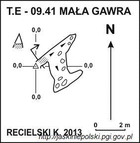
Mała Gawra – a cave, or rather a shelter, in the Kościeliska Valley in the Western Tatras. The entrance to it is located in the Kraków Gorge, on the slope of Upłazkowa Turnia descending to the Upłazkowy Kocioł, near the Gawra Cave and the Lamb Cave, at an altitude of 1300 meters above sea level. The length of the cave is 6 meters, and its denivelation is 2 meters.
57. Spękana Szczelina

Cracked Rift – a cave in the Kościeliska Valley in the Western Tatras. The entrance to it is located in the Kraków Gorge, on the slope descending from Upłazkowa Turnia, near the Cave at Perć, at an altitude of 1230 m above sea level. The length of the cave is 11.5 meters, and its height difference is 5 meters.
58. Zimna Szczelina Trzecia
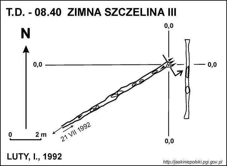
Zimna Szczelina III – a cave, or rather a shelter, in the Kościeliska Valley in the Western Tatras. The entrance to it is located above the rocks of Sowa, near the Cold Rift I and Cold Rift II caves, at an altitude of 1117 meters above sea level. The length of the cave is 8 meters, and its denivelation is 4 meters.
59. Sowia Jama Trzecia

Owl Cave III – a cave, or rather a shelter, in the Kościeliska Valley in the Western Tatras. The entrance to it is located above the Sowa River, at an altitude of 1060 meters above sea level. The cave is horizontal and its length is 5 meters.
60. Gładka Turnia
Gładka Turnia – a small crag in the orographically right slopes of the Kraków Gorge in the Western Tatras. It is located in the south-western ridge descending from the top of Upłazkowa Turnia, slightly above Ptakowa Turnia. Kraków descends to the Gorge with a rock wall, which is limited from the left by a shallow gutter overgrown here and there with clumps of grass, and from the right by a chimney with troughs. In the wall there is a smooth slab with a rather prominent pillar falling to the south, covered with eaves from the top. This pillar led a climbing route with two lifts. The first ascent: Dariusz Stawarz and Jacek Stawarz on August 18, 1995. This peak is separated by a small west from the main south-western ridge of Upłazkowa Turnia.
61. Upłazkowy Kopiniak
Upłazkowy Kopiniak – a crag in the central part of Upłazkowa Ridge in the Polish Western Tatras. Its northern wall, about 40 m high, descends to the Pisanski Żleb, while the southern wall to the Upłazkowy Kotło in the Kraków Gorge. The southern wall is about 120 m high and it is the highest wall in the entire Upłazkowa Turnia massif. Both have not yet been climbed by mountaineers. On the other hand, from Upłazkowy Przechod you can go to Upłazkowy Kopiniak without difficulty.
62. Kresanica / Krzesanica

Krzesanica is a mountain in the Western Tatras mountain range, situated on the main ridge of the Tatras between Ciemniak and Małołączniak, on the Polish-Slovak border. It is the highest of the four peaks making up the Czerwone Wierchy group of peaks. It is also the highest limestone peak in Western Tatras and in Poland.
63. Malolučniak / Małołączniak

Małołączniak is a mountain in the Western Tatras mountain range, situated on the main ridge of the Tatras between Krzesanica and Kopa Kondracka, on the Polish-Slovak border. It is one the four peaks making up the Czerwone Wierchy group of peaks.
Share
How likely are you to recommend us?
Disclaimer Please be aware of your surroundings and do not enter private property. We are not liable for any damages that occur during the tours.