56 Sights in Sydney, Australia (with Map and Images)
Legend
Premium Sights
Book tickets, guided tours and activities in Sydney.
Guided Free Walking Tours
Book free guided walking tours in Sydney.
Welcome to your journey through the most beautiful sights in Sydney, Australia! Whether you want to discover the city's historical treasures or experience its modern highlights, you'll find everything your heart desires here. Be inspired by our selection and plan your unforgettable adventure in Sydney. Dive into the diversity of this fascinating city and discover everything it has to offer.
Sightseeing Tours in SydneyActivities in Sydney
Darling Harbour is a harbour adjacent to the city centre of Sydney, New South Wales, Australia that is made up of a large recreational and pedestrian precinct that is situated on western outskirts of the Sydney central business district.

Cadmans Cottage or Cadman's Cottage is a heritage-listed former water police station and sailor's home and now visitor attraction located at 110 George Street in the inner city Sydney suburb of The Rocks in the City of Sydney local government area of New South Wales, Australia. The property is owned by Department of Planning & Environment, an agency of the Government of New South Wales. It was added to the New South Wales State Heritage Register on 2 April 1999.

The Chinese Garden of Friendship is a heritage-listed 1.03-hectare (3-acre) Chinese garden at 1 Harbour Street, in the Sydney Central Business District, New South Wales, Australia. Modelled after the classic private gardens of the Ming dynasty, the garden offers an insight into Chinese heritage and culture. It was designed by Guangzhou Garden Planning & Building Design Institute, Tsang & Lee, and Edmond Bull & Corkery. It was built between 1986-1988 by Gutteridge Haskins & Davey, the Darling Harbour Authority, Imperial Gardens, Leightons, and Australian Native Landscapes. The gardens were added to the New South Wales State Heritage Register on 5 October 2018.

The Museum of Sydney is a historical collection and exhibit, built on the ruins of the house of New South Wales' first Governor, Arthur Phillip, on the present-day corner of Phillip and Bridge Street, Sydney.

The Australian National Maritime Museum (ANMM) is a federally operated maritime museum in Darling Harbour, Sydney. After considering the idea of establishing a maritime museum, the federal government announced that a national maritime museum would be constructed at Darling Harbour, tied into the New South Wales state government's redevelopment of the area for the Australian bicentenary in 1988. The museum building was designed by Philip Cox, and although an opening date of 1988 was initially set, construction delays, cost overruns, and disagreements between the state and federal governments over funding responsibility pushed the opening to 1991.
Wikipedia: Australian National Maritime Museum (EN), Website

Wild Life Sydney Zoo is a wildlife park in the Darling Harbour precinct, on the western edge of the Sydney central business district, Australia. Opened in September 2006, the zoo is located adjacent to a leisure and retail precinct that includes the Sea Life Sydney Aquarium and Madame Tussauds Sydney.

The Archibald Fountain, properly called the J. F. Archibald Memorial Fountain, is located in Hyde Park, in central Sydney. It is named after J. F. Archibald, owner and editor of The Bulletin magazine, who bequeathed funds to have it built. Archibald specified that it must be designed by a French artist, both because of his great love of French culture and to commemorate the association of Australia and France in World War I. He wished Sydney to aspire to Parisian civic design and ornamentation. The artist chosen was François-Léon Sicard, who completed it in Paris in 1926 but never saw the sculpture be placed in Sydney, where it was unveiled on 14 March 1932 by the Lord Mayor of Sydney, Samuel Walder.

The Hyde Park Barracks, Sydney is a heritage-listed former barracks, hospital, convict accommodation, mint and courthouse and now museum and café located at Macquarie Street in the Sydney central business district, in the City of Sydney local government area of New South Wales, Australia. Originally constructed between 1817 and 1819 as a brick building and compound to house convict men and boys, it was designed by convict architect Francis Greenway. It is also known as the Mint Building and Hyde Park Barracks Group and Rum Hospital; Royal Mint – Sydney Branch; Sydney Infirmary and Dispensary; Queen's Square Courts; Queen's Square. The site is managed by the Museums of History New South Wales, an agency of the Government of New South Wales, as a living history museum open to the public.

Forgotten Songs is a public artwork by Michael Thomas Hill located in Angel Place, Sydney. The installation was part of the 2009 Sydney Laneway Temporary art scheme, afterwards, due to the popularity of the installation, in 2011, the project was turned into a part of the 9 million dollar permanent laneway installations.

Sydney Tower, also known as Westfield Tower and formerly as Centrepoint Tower, is an observation and telecommunications tower that is the tallest structure in Sydney, New South Wales, Australia, as well as the second-tallest observation tower in the Southern Hemisphere. Sydney Tower has also previously been known as AMP Tower, and colloquially as Flower Tower, Glower Tower, and Big Poke.

The Queen Victoria Building is a heritage-listed late-nineteenth-century building located at 429–481 George Street in the Sydney central business district, in the state of New South Wales, Australia. Designed by the architect George McRae, the Romanesque Revival building was constructed between 1893 and 1898 and is 30 metres (98 ft) wide by 190 metres (620 ft) long. The domes were built by Ritchie Brothers, a steel and metal company that also built trains, trams and farm equipment. The building fills a city block bounded by George, Market, York, and Druitt Streets. Designed as a marketplace, it was used for a variety of other purposes, underwent remodelling, and suffered decay until its restoration and return to its original use in the late twentieth century. The property is co-owned by the City of Sydney and Link REIT, and was added to the New South Wales State Heritage Register on 5 March 2010.

The Art Gallery of New South Wales (AGNSW), founded as the New South Wales Academy of Art in 1872 and known as the National Art Gallery of New South Wales between 1883 and 1958, is located in The Domain, Sydney, Australia. It is the most important public gallery in Sydney and one of the largest in Australia.
The Star Sydney in Pyrmont, Sydney, is the second largest casino in Australia after Melbourne's Crown Casino. Overlooking Darling Harbour, The Star, owned by Star Entertainment Group features two gaming floors, one bar, 3 restaurants, 351 hotel rooms and 130 serviced and privately owned apartments. It also includes the 2,000 seat Sydney Lyric theatre and 3,000-seat Event Centre, the latter designed by Montreal-based theatre design firm Scéno Plus. Its gaming operations are overseen and controlled by the New South Wales Casino Control Authority and is licensed to be the only legal casino in New South Wales. In late 2007, it was granted a 12-year extension of its exclusivity and licence.
14. St James Church
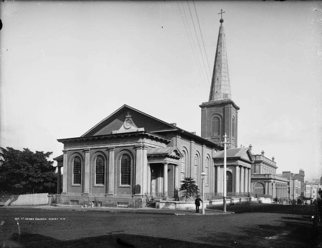
St James' Church, commonly known as St James', King Street, is an Australian heritage-listed Anglican parish church located at 173 King Street, in the Sydney central business district in New South Wales. Consecrated in February 1824 and named in honour of St James the Great, it became a parish church in 1835. Designed in the style of a Georgian town church by the transported convict architect Francis Greenway during the governorship of Lachlan Macquarie, St James' is part of the historical precinct of Macquarie Street which includes other early colonial era buildings such as the World Heritage listed Hyde Park Barracks.
15. St Mary's Cathedral

The Cathedral Church and Minor Basilica of the Immaculate Mother of God, Help of Christians, Patroness of Australia is the cathedral church of the Roman Catholic Archdiocese of Sydney and the seat of the Archbishop of Sydney, currently Anthony Fisher OP. It is dedicated to the "Immaculate Mother of God, Help of Christians", Patroness of Australia and holds the title and dignity of a minor basilica, bestowed upon it by Pope Pius XI on 4 August 1932.
16. St Andrews Cathedral

St Andrew's Cathedral is a cathedral church of the Anglican Diocese of Sydney in the Anglican Church of Australia. The cathedral is the seat of the Anglican Archbishop of Sydney and Metropolitan of New South Wales. The position of Dean of Sydney has been held by the Very Reverend Sandy Grant since 9 December 2021.
17. Powerhouse Museum
The Powerhouse Museum, formerly known as the Museum of Applied Arts & Sciences (MAAS), is a collection of museums in Sydney, and owned by the Government of New South Wales. Its main centre is in Ultimo, New South Wales, the others being the historic Sydney Observatory at Observatory Hill, and the newer Powerhouse Castle Hill at Castle Hill. Powerhouse Parramatta is due to open in 2025.
18. Museum of Contemporary Art
The Museum of Contemporary Art Australia (MCA), formerly the Museum of Contemporary Art, Sydney, is located on George Street in The Rocks neighbourhood of Sydney. The museum is housed in the Stripped Classical/Art Deco-styled former Maritime Services Board (MSB) building on the western side of Circular Quay. A modern wing was added in 2012.
Wikipedia: Museum of Contemporary Art Australia (EN), Website
19. Australian Museum

The Australian Museum, originally known as the Colonial Museum or Sydney Museum. is a heritage-listed museum at 1 William Street, Sydney CBD, New South Wales. It is the oldest natural history museum in Australia and the fifth oldest natural history museum in the world, with an international reputation in the fields of natural history and anthropology.
20. Hordern Pavilion

Hordern Pavilion is a building located in Moore Park, Sydney, New South Wales, Australia, on the grounds of the old Sydney Showground. Now known as a sports venue, dance party and music concert venue, the Hordern Pavilion was originally constructed for the Royal Agricultural Society of New South Wales to meet the increasing demands for exhibition space at the Royal Easter Show. Hordern's undeniable importance was a rather unique use WWII as a bulk store for the Army.
21. Christ Church St Laurence

Christ Church St Laurence is an Anglican church located at 814 George Street, near Central railway station and Haymarket, in Sydney, New South Wales, Australia. It is the principal centre of Anglo-Catholic worship in the city and Diocese of Sydney, where the Anglicanism is predominantly Evangelical in character. Anglo-Catholicism is manifested at Christ Church St Laurence by an emphasis on the sacraments, ritual, music and social action, all of which have been prominent features of Anglo-Catholicism since the 19th century.
22. Capitol Theatre

The Capitol Theatre is a heritage-listed theatre located at 3-15 Campbell Street, Haymarket, in the Sydney central business district, Australia. It was designed by Henry Eli White and John Eberson and built from 1893 to 1928. The property was added to the New South Wales State Heritage Register on 2 April 1999. The former circus venue, atmospheric theatre and market venue in owned by Capitol Theatre Management Pty Limited, a wholly owned subsidiary of Foundation Theatres Pty Limited. Foundation Theatres owns the Sydney Lyric and Capitol Theatre.
23. Government House

Government House is the heritage-listed vice-regal residence of the governor of New South Wales. It is located on Conservatorium Road in the Sydney central business district, adjacent to the Royal Botanic Garden, and is situated south of the Sydney Opera House, overlooking Sydney Harbour. Constructed between 1837 and 1843, the property has been the primary vice-regal residence of the Governor since Sir George Gipps, except for two brief periods; the first between 1901 and 1914, when the property was leased to the Commonwealth of Australia as the residence of the Governor-General of Australia, and the second from 1996 to 2011.
24. Sydney Park

Sydney Park is a 41.6-hectare (103-acre) recreational area in the inner-city area of Sydney, New South Wales, Australia. The parkland is located in the suburb of Alexandria, sitting along the borders with Newtown and Erskineville.
25. State Theatre

The State Theatre is a 2034 seat heritage listed theatre located at 47–51 Market Street, in the Sydney central business district in the City of Sydney local government area of New South Wales, Australia. The theatre was designed by Henry Eli White with assistance from John Eberson and built between 1926 and 1929. It hosts film screenings, live theatre and musical performances, and since 1974 it has been the home of the annual Sydney Film Festival. It is also known as State Building and Wurlitzer Organ. The property is privately owned. It was added to the New South Wales State Heritage Register on 2 April 1999.
26. HMAS Onslow

HMAS Onslow is one of six Oberon-class submarines, previously operated by the Royal Australian Navy (RAN). The submarine was named after the town of Onslow, Western Australia, and Sir Alexander Onslow, with the boat's motto and badge derived from Onslow's family heritage. Ordered in 1963, Onslow was laid down at the end of 1967 by Scotts Shipbuilding and Engineering Company in Scotland, launched almost a year later, and commissioned into the RAN at the end of 1969.
27. Sydney Observatory
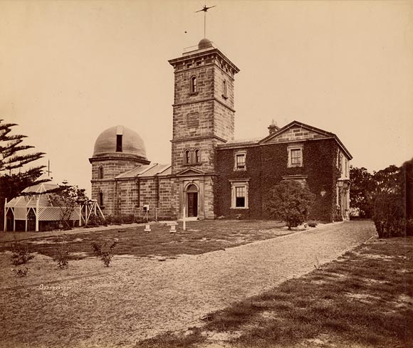
The Sydney Observatory is a heritage-listed meteorological station, astronomical observatory, function venue, science museum, and education facility located on Observatory Hill at Upper Fort Street, in the inner city Sydney suburb of Millers Point in the City of Sydney local government area of New South Wales, Australia. It was designed by William Weaver (plans) and Alexander Dawson (supervision) and built from 1857 to 1859 by Charles Bingemann & Ebenezer Dewar. It is also known as The Sydney Observatory; Observatory; Fort Phillip; Windmill Hill; and Flagstaff Hill. It was added to the New South Wales State Heritage Register on 22 December 2000.
28. HMAS Vampire

HMAS Vampire was the third of three Australian-built Daring-class destroyers serving in the Royal Australian Navy (RAN). One of the first all-welded ships built in Australia, she was constructed at Cockatoo Island Dockyard between 1952 and 1959, and was commissioned into the RAN a day after completion.
29. Great Synagogue

The Great Synagogue is an Orthodox Jewish congregation located in a large heritage-listed synagogue at 187a Elizabeth Street in the Sydney central business district in the City of Sydney in New South Wales, Australia.
30. Pyrmont Bridge

The Pyrmont Bridge, a heritage-listed swing bridge across Cockle Bay, is located in Darling Harbour, part of Port Jackson, west of the central business district in the City of Sydney local government area of New South Wales, Australia. Opened in 1902, the bridge initially carried motor vehicle traffic via the Pyrmont Bridge Road between the central business district and Pyrmont. Since 1981 the bridge has carried pedestrian and bicycle traffic only, as motor vehicles were diverted to adjacent freeway overpasses. The bridge was added to the New South Wales State Heritage Register on 28 June 2002, the centenary of its opening.
31. Sydney Lyric
Sydney Lyric is a theatre in Sydney, New South Wales, Australia. It is part of The Star complex. The theatre is used for large scale musicals, theatre productions, concerts, opera and ballet. Formerly the Lyric Theatre, the venue changed to its current name in late 2011.
32. Sydney Jewish Museum

The Sydney Jewish Museum is a history museum located in the Sydney suburb of Darlinghurst. It showcases exhibits relating to the Holocaust and the history and achievements of Jewish people in Australia. The Museum displays personal objects of Holocaust survivors and other Jewish Australians and hosts presentations of their personal testimonies.
33. Yininmadyemi - Thou didst let fall

Yininmadyemi - Thou didst let fall is a sculptural artwork by Indigenous Australian artist Tony Albert located in Hyde Park, Sydney. Unveiled on 31 March 2015, the artwork acknowledges the service of Aboriginal and Torres Strait Islander men and women in the Australian Defence Force.
34. The Mint

The Sydney Mint in Sydney, New South Wales, Australia, is the oldest surviving public building in the Sydney central business district. Built between 1811 and 1816 as the southern wing of the Sydney Hospital, it was then known as the Rum Hospital. In 1854 a mint was established on the site with the hospital building used to house mint staff as well as providing a residence for the Deputy Mint Master. A coining factory was built at the rear. Both of these structures have exceptional heritage significance and have been associated with major events in the colonial history of New South Wales.
35. HMAS Advance

HMAS Advance was an Attack-class patrol boat of the Royal Australian Navy (RAN). Constructed during 1967 and commissioned into the RAN in 1968, Advance operated from Darwin and patrolled northern Australian waters.
36. AWA Tower

The AWA Tower is a heritage-listed office and communications complex in Sydney, in the state of New South Wales, Australia built for AWA. The AWA Tower consists of a radio transmission tower atop a 15-storey building. It is located in the Sydney central business district at 45-47 York Street, close to Wynyard Park and Wynyard railway station. It was designed by Robertson, Marks and McCredie in association with DT Morrow and Gordon and built from 1937 to 1939 by William Hughes and Co. Pty Ltd. It was added to the New South Wales State Heritage Register on 2 April 1999.
37. City Recital Hall

City Recital Hall in Sydney, Australia, is a purpose-built concert venue with the capacity for an audience of 1,238 people seated over three tiers of sloped seating. It is situated in the city centre in Angel Place, just off Martin Place.
38. Queen Victoria Monument

The seated Statue of Queen Victoria, currently in Sydney, New South Wales, Australia, was made by John Hughes in 1908 and was originally located in Dublin. Made of bronze, it is situated on the corner of Druitt and George Street in front of the Queen Victoria Building. It was the last royal statue to have been erected in Ireland.
39. Halo

Halo is a wind powered kinetic sculpture in Sydney, Australia. Located at Central Park, the artwork is part of a major mixed-use urban renewal project to redevelop the old Kent Brewery site in Broadway.
40. Wynyard Park

Wynyard Park is a 0.7-hectare (2-acre) urban park in the Sydney central business district, in Sydney, New South Wales, Australia. Wynyard Park is bounded by York, Carrington, Margaret and Wynyard Streets. Surrounded by modern high-rise buildings it is one of the most densely built-up and intensively used parks in Sydney. Entrances to Wynyard railway station are located on the north-eastern and north-western corners of the park.
41. Sydney Gay and Lesbian Holocaust Memorial

The Sydney Gay and Lesbian Holocaust Memorial Project was founded by a group of community activists. Over the years they raised funds and decided, with South Sydney City Council, on the site at Green Park in Darlinghurst, in Sydney, Australia. Darlinghurst is considered the heart of Sydney's gay and lesbian population. Green Park is adjacent to the Sydney Jewish Museum, which ensures that the memorial retains its historic meaning.
42. Fort Denison Light

Fort Denison Light, also known as Pinchgut Light, is an active lighthouse located on top of a Martello Tower at Fort Denison, a former penal site and defensive facility occupying a small island in Sydney Harbour, New South Wales, Australia. The island is located downstream from the Harbour Bridge near Potts Point and the Royal Botanic Gardens. The fort is also known as "Pinchgut" lending its name to the light.
43. Devonshire Street Pedestrian Tunnel

The Devonshire Street Tunnel is a 300-metre-long (980 ft) pedestrian tunnel located beneath the southern end of Central station connecting the suburb of Surry Hills with Railway Square in the Sydney central business district.
44. Phoenix Central Park

Phoenix Central Park is a performing arts venue and private art gallery located at 37-49 O'Connor Street, Chippendale, New South Wales, Australia. The location is within the Chippendale Heritage Conservation Area (HCA), item ‘C9’ on Schedule 5 of the Sydney Environmental Plan (LEP) 2012. The site is also within the Chippendale Locality as described in Section 2.3.1 of the Sydney Development Control Plan (DCP) 2012.
45. Belmore Park
Belmore Park is a public park at the southern end of the Sydney central business district in the Australian state of New South Wales. Adjacent to the Central railway station, the park is bounded by Hay Street, Eddy Avenue, Elizabeth Street and Pitt Street. The area was previously known as Police Paddock and was part of a section of Crown land which included the Police Barracks, Devonshire Street Cemetery, Female Refuge of the Good Samaritan, Benevolent Asylum and a common.
46. Justice & Police Museum

The Justice and Police Museum is a heritage-listed former water police station, offices and courthouse and now justice and police museum located at 4-8 Phillip Street on the corner of Albert Street, in the Sydney central business district in the City of Sydney local government area of New South Wales, Australia. It was designed by Edmund Blacket, Alexander Dawson and James Barnet and built from 1854 to 1886. It is also known as Police Station & Law Courts (former) and Traffic Court. The property is owned by the Department of Justice, a department of the Government of New South Wales. It was added to the New South Wales State Heritage Register on 2 April 1999.
47. Argyle Cut

The Argyle Cut is a heritage-listed roadway and road cutting located at Argyle Street in the inner-city Sydney suburb of The Rocks in the City of Sydney local government area of New South Wales, Australia. It was built from 1843 to 1868 with convict and paid labour. The property is owned by the Sydney Harbour Foreshore Authority, an agency of the Government of New South Wales. It was added to the New South Wales State Heritage Register on 10 May 2002.
48. St Brigid's Church

St Brigid's Roman Catholic Church is a heritage-listed Roman Catholic church building located at 14, 16 Kent Street, in the inner city Sydney suburb of Millers Point, New South Wales, Australia. It is also known as St. Brigid's Roman Catholic Church & School, St Brigid's, and St Bridget's. The property is owned by Saint Brigid's Roman Catholic Church. It was added to the New South Wales State Heritage Register on 2 April 1999.
49. Biloela House

Biloela House is a house at the centre of a heritage-listed historic precinct on Cockatoo Island, Sydney Harbour, New South Wales, Australia. It was added to the Australian Commonwealth Heritage List on 22 June 2004.
50. Man O' War Steps

The Man O'War Steps is a heritage-listed jetty located at Farm Cove Crescent, in the Sydney central business district, in the City of Sydney local government area of New South Wales, Australia. It was built from 1810. The property is owned by Transport for NSW. It was added to the New South Wales State Heritage Register on 18 April 2000. The Steps are located on the eastern bank of Bennelong Point, adjacent to the Sydney Opera House and on the north-western boundary of the Royal Botanic Garden.
51. Tumbalong Park

Tumbalong Park is a park in Darling Harbour, Sydney, Australia. The park was designed using native Australian foliage decorated with fountains as an urban stream. The name "Tumbalong" is from Dharug as spoken by the Eora people and means "place where seafood is found".
52. Newtown Mission

The Newtown Mission Uniting Church is a heritage-listed Uniting church at 280a King Street, Newtown, City of Sydney, New South Wales, Australia. It was designed by George Allen Mansfield and built in 1859 by Thomas Abbott. It was added to the New South Wales State Heritage Register on 2 April 1999.
53. Dalgety's Bond Store A

Dalgety's Bond Stores is a heritage-listed former warehouse complex and now commercial building located at Munn Street, in the inner city Sydney suburb of Millers Point in the City of Sydney local government area of New South Wales, Australia. It was built in 1875. It is also known as Munn Street Bond Stores. It was added to the New South Wales State Heritage Register on 2 April 1999.
54. Darling Harbour Carousel

The Darling Harbour Carousel is a heritage-listed carousel located at the concourse under the Western Distributor at Darling Harbour in the Sydney central business district in the City of Sydney local government area, New South Wales, Australia. It is also known as The Carousel. It was added to the New South Wales State Heritage Register on 28 June 2002.
55. University Hall

The University Hall and Cottages is a heritage-listed former hotel and now student accommodation located at 281–285 Broadway in the inner western Sydney suburb of Glebe in the City of Sydney local government area of New South Wales, Australia. It was added to the New South Wales State Heritage Register on 2 April 1999.
56. Harmony Park

Park is Harmony Park in Australia. It is located in the state of New South Wales, in the southeastern part of the country, 250 km northeast of Canberra with the capital. 47 meters above sea level is located in Harmony Park.
Wikipedia: Harmony Park (parke sa Ostralya, State of New South Wales) (CEB), Website
Share
How likely are you to recommend us?
Disclaimer Please be aware of your surroundings and do not enter private property. We are not liable for any damages that occur during the tours.