37 Sights in Brisbane, Australia (with Map and Images)
Legend
Premium Sights
Book tickets, guided tours and activities in Brisbane.
Guided Free Walking Tours
Book free guided walking tours in Brisbane.
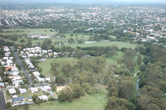
Welcome to your journey through the most beautiful sights in Brisbane, Australia! Whether you want to discover the city's historical treasures or experience its modern highlights, you'll find everything your heart desires here. Be inspired by our selection and plan your unforgettable adventure in Brisbane. Dive into the diversity of this fascinating city and discover everything it has to offer.
Sightseeing Tours in BrisbaneActivities in Brisbane
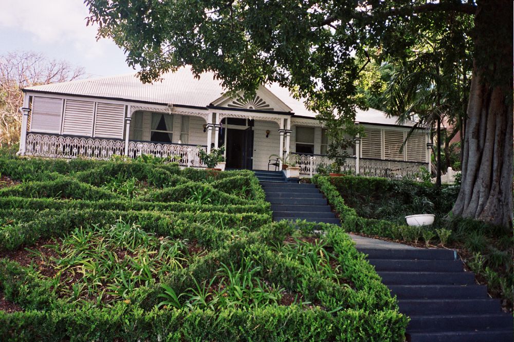
Newstead House is Brisbane's oldest surviving residence and is located on the Breakfast Creek bank of the Brisbane River, in the northern Brisbane suburb of Newstead, in Queensland, Australia. Built as a small cottage in the Colonial-Georgian style in 1846, the cottage was extended and today is painted and furnished in a late Victorian style.

ANZAC Square is a heritage-listed town square and war memorial located between Ann Street and Adelaide Street, in Brisbane, Queensland, Australia. It is a state memorial to the men and women who participated in overseas armed service and is named in honour of the Australian and New Zealand Army Corps. ANZAC Square is adjacent to ANZAC Square Arcade.

The City Botanic Gardens is a heritage-listed botanic garden on Alice Street, Brisbane City, City of Brisbane, Queensland, Australia. It was also known as Queen's Park. It is located on Gardens Point in the Brisbane CBD and is bordered by the Brisbane River, Alice Street, George Street, Parliament House and Queensland University of Technology's Gardens Point campus. It was established in 1825 as a farm for the Moreton Bay penal settlement.
4. Boggo Road Gaol

H.M. Prison Brisbane, commonly known as Boggo Road Gaol, was Queensland's main prison from the 1880s to the 1980s. By the time it closed, it had become notorious for poor conditions and rioting. Located on Annerley Road in Dutton Park, an inner southern suburb of Brisbane, it is the only surviving intact gaol in Queensland that reflects penological principles of the 19th century. After closing in 1992, the larger 1960s section was demolished, leaving the heritage listed section.
5. Cremorne Theatre

The Cremorne Theatre was a theatre in South Brisbane, Brisbane, Queensland, Australia that operated, with interruptions, from 1911 to 1954. Although nothing remains of it today, the general location retains its cultural significance from the first half of the twentieth century as a theatre precinct, thanks to the nearby construction of Queensland Performing Arts Centre (QPAC) in 1985. Its name lives on in the new Cremorne Theatre, one of the venues within QPAC.
6. Holy Trinity Anglican Church

Holy Trinity Anglican Church is a heritage-listed Anglican church at 68 Hawthorne Street, Woolloongabba, Brisbane, Queensland, Australia. Since 1869, three church buildings have stood on this hill top site. The current church was completed in 1930. It was designed by the architect Eric Ford, featuring Romanesque and Spanish Mission Revival style architecture. Its preserved original architectural features make the church a traditional wedding venue of inner Brisbane. The church was added to the Queensland Heritage Register on 9 May 2008.
Wikipedia: Holy Trinity Anglican Church, Woolloongabba (EN), Website
7. Roma Street Parklands

Roma Street Parkland covers 11 hectares in the centre of the City of Brisbane, Queensland, Australia. The Roma Street Parkland is adjacent to the former Brisbane Transit Centre and the Roma Street railway station from which it takes its name. There is pedestrian access to the Roma Street Parkland from the Roma Street railway station, as well as from Albert Street, and from the section of the Parkland which was formerly called Albert Park on Wickham Terrace. Roma Street Parkland is open to visitors 24 hours a day, except for the Spectacle Garden and Rainforest Walk, which are open daily from dawn until dusk.
8. Tangalooma Wrecks

Originally a whaling station, Tangalooma Island Resort is a resort on the west side of Moreton Island in Queensland, Australia. It lies on the eastern shore of Moreton Bay and is known for its resort accommodation, dolphin-feeding program, sand dunes and wreck diving. Swimming is popular along the white beaches. It has a population of over 300 and receives more than 3,500 visitors every week as it is about 70 minutes from Brisbane by express catamaran. Moreton Island National Park covers 98% of the island, though there are three small townships including Bulwer, Kooringal and Cowan. The adjacent waters are protected as the Moreton Bay Marine Park. Tangalooma is the aboriginal word meaning "where the fish gather".
9. Walter Taylor Bridge

The Walter Taylor Bridge is a heritage-listed suspension bridge crossing the Brisbane River between Indooroopilly and Chelmer in Brisbane, Queensland, Australia. It is shared by motor traffic and pedestrians and is the only habitable bridge in the Southern Hemisphere. It was originally known as the Indooroopilly Toll Bridge. The bridge footpath will be closed from 26 August to 30 September 2024 general maintenance.
10. Cathedral of Saint Stephen

The Cathedral of St Stephen is the heritage-listed cathedral church of the Roman Catholic Archdiocese of Brisbane and seat of its archbishop in Brisbane, Queensland, Australia. St Stephen's was only meant to serve as a temporary seat for the archbishop, and plans for a replacement were made with the Holy Name Cathedral, however the cathedral was never built.
11. Commissariat Store

The Commissariat Store is a heritage-listed storehouse at 115–127 William Street, Brisbane City, City of Brisbane, Queensland, Australia. It is bordered by William Street, Queen's Wharf Road and the Brisbane River, and is the birthplace of Queensland. It was designed by William John Dumaresq and built from 1828 to 1913 by convict labour under the direction of Captain Logan as a permanent Commissariat Store for the Moreton Bay penal settlement. It is also known as Government Stores, State Stores Building, and Colonial Store. It was added to the Queensland Heritage Register on 21 October 1992.
12. Albert Bridge

Albert Bridge is a heritage-listed railway bridge of steel truss design crossing the Brisbane River between Indooroopilly and Chelmer in the City of Brisbane, Queensland, Australia. It was designed by Henry Charles Stanley and built from 1894 to 1895 by John McCormick & Son as a replacement for an earlier bridge lost to flooding in 1893. Both bridges were named in honour of the Prince of Wales, Prince Albert. It was added to the Queensland Heritage Register on 21 October 1992.
13. New Farm Park

New Farm Park is a heritage-listed riverfront public park at 137 Sydney Street, New Farm, City of Brisbane, Queensland, Australia. It was designed by Albert Herbert Foster and built from 1914 to 1950 by Gladwin Legge & Co. It was added to the Queensland Heritage Register on 7 February 2005.
14. Kalinga Park
Kalinga Park is a heritage-listed park at 100 Bertha Street, Kalinga, City of Brisbane, Queensland, Australia. The eastern section of the park borders neighbouring Clayfield. It is also known as Anzac Memorial Park. It was added to the Queensland Heritage Register on 3 July 2007.
15. The Mansions

The Mansions is a heritage-listed row of six terrace houses at 40 George Street, Brisbane City, City of Brisbane, Queensland, Australia. It was designed by G.H.M. Addison and built in 1889 by RE Burton. It was added to the Queensland Heritage Register on 21 August 1992.
16. HMAS Diamantina

HMAS Diamantina (K377/F377/A266/GOR266), named after the Diamantina River in Queensland, is a River-class frigate that served the Royal Australian Navy (RAN). Constructed in the mid-1940s, Diamantina was active from 1945 until 1946, was placed in reserve, then was recommissioned as a survey ship from 1959 until 1980.
17. Queen's Gardens

Queens Gardens is a heritage-listed park located on a city block between George Street, Elizabeth Street and William Street in the Brisbane CBD, City of Brisbane, Queensland, Australia. It was built from c. 1905 to 1990s. It is also known as Executive Gardens and St Johns Church Reserve. It was added to the Queensland Heritage Register on 21 October 1992.
18. Customs House

Customs House is a heritage-listed customs house at 427 Queen Street, Brisbane CBD, Brisbane, Queensland, Australia. It was designed by Charles H McLay and built from 1886 to 1889 at a cost of £38,346 by John Petrie & Son. It was originally used for the collection of customs duty and was opened in 1889, when Queensland was a British colony, replacing the original Customs House located at Petrie Bight. It was added to the Queensland Heritage Register on 7 February 2005.
19. Old Museum

The Old Museum Building is a heritage-listed former exhibition building, former museum and now performance venue in Bowen Hills, Brisbane, Queensland, Australia. It is made from 1.3 million red bricks and bordered by Gregory Terrace and the Exhibition Grounds.
20. Saint Andrews

St Andrew's Uniting Church is a heritage-listed Uniting church at 131 Creek Street, Brisbane CBD, City of Brisbane, Queensland, Australia. It was designed by George David Payne and built in 1905 by Alexander Lind & Son. Initially St Andrew's Presbyterian Church, it became part of the Uniting Church following the merger of the Presbyterian, Methodist and Congregational Churches in 1977. It was added to the Queensland Heritage Register on 21 October 1992.
21. Chinatown

Chinatown, Brisbane is a precinct in Fortitude Valley, Brisbane, Australia. It is centred on Chinatown Mall, a pedestrian street which occupies all of Duncan Street. The Mall runs parallel to Brunswick Street Mall, and connects Wickham Street and Ann Street. The precinct is the location of Chinese restaurants and shops, and is the venue for events including Chinese New Year and Valley Fiesta. Street signs in the area are written in both English and Chinese. It is also home to many restaurants offering Chinese, Korean, Indonesian, Japanese, Thai and Vietnamese cuisines. Its pan-Asian nature is also emphasized through the hosting of many Asian festivals including the annual Indian festival, Diwali.
22. Forceful

Forceful was a sea-going tugboat built for the Queensland Tug Company by Alexander Stephen and Sons Ltd in Govan, Scotland in 1925. She worked at her homeport of Brisbane, Australia between 1926 and 1970 berthing ships and assisting nearby casualties. During World War II she was commissioned into the Royal Australian Navy in early 1942 as HMAS Forceful (W126), based at Fremantle and Darwin, until returning to commercial service in October 1943. She was preserved as a museum ship until 2023 when she was scrapped.
23. Yeronga Memorial Park

Yeronga Memorial Park is a heritage-listed park at Ipswich Road, Yeronga, City of Brisbane, Queensland, Australia. The park has an area of 224,600 square metres (2,418,000 sq ft) and is one of the oldest in Brisbane, having been established in 1882, and has been a World War I memorial since 1917. It was added to the Queensland Heritage Register on 2 December 2005.
24. Eagle Farm Women's Prison and Factory - Prison pallisade gate

Eagle Farm Women's Prison and Factory Site is a heritage-listed archaeological site at 116 Lamington Avenue, Eagle Farm, City of Brisbane, Queensland, Australia. It operated between 1829 and 1839 as part of the Moreton Bay penal settlement. It is on the site now part of the Australia TradeCoast, previously the Eagle Farm Airport. It was added to the Queensland Heritage Register on 7 February 2005.
25. Victoria Bridge Abutment

Victoria Bridge Abutment is a heritage-listed road bridge remnant at 74 Stanley Street, South Brisbane, City of Brisbane, Queensland, Australia. It was designed by Alfred Barton Brady and built in 1896 by Arthur Midson. It was added to the Queensland Heritage Register on 21 August 1992.
26. Albert Street Uniting Church

Albert Street Uniting Church is a heritage-listed Uniting church at 319 Albert Street, Brisbane City, City of Brisbane, Queensland, Australia. It was designed by George Henry Male Addison and built from 1888 to 1889 by Thomas Pearson & Sons. It was originally known as Albert Street Methodist Church and Central Methodist Mission. It was added to the Queensland Heritage Register on 21 October 1992.
27. Centenary Place

Centenary Place is a heritage-listed park at 85 Wickham Street, Fortitude Valley, City of Brisbane, Queensland, Australia. It is also known by some as Centenary Park even though this is not the name it was given at the ceremonial dedication. It was designed by Henry Moore. It was added to the Queensland Heritage Register on 6 August 2007.
28. Sir William Glasgow Memorial

The Sir William Glasgow Memorial is a heritage-listed statue of Sir William Glasgow in Post Office Square at 270 Queen Street, Brisbane CBD, City of Brisbane, Queensland, Australia. It was designed by Daphne Mayo and built from 1961 to 1964. It was added to the Queensland Heritage Register on 13 May 2004.
29. Mowbray Park

Mowbray Park and East Brisbane War Memorial are a heritage-listed park and monument within the park on Lytton Road, East Brisbane, Queensland, Australia. It was built from 1904 to 1974. It is also known as East Brisbane War Memorial and Riversdale. It was added to the Queensland Heritage Register on 21 October 1992.
30. St John the Baptist

St John the Baptist Anglican Church is a heritage-listed church at 171 Oxford Street, Bulimba, Brisbane, Queensland, Australia. It was designed by John Hingeston Buckeridge and built in 1888 by T Whitty. It was added to the Queensland Heritage Register on 9 July 2003.
Wikipedia: St John the Baptist Anglican Church, Bulimba (EN), Website
31. Sherwood Arboretum

Sherwood Arboretum is a heritage-listed arboretum at 39A Turner Street, Sherwood, Queensland, Australia. A 1946 addition to the site is also known as the John Herbert Memorial Vista. It was added to the Queensland Heritage Register on 3 May 2007.
32. 'Amity'
Amity is a heritage-listed detached house at 101 Welsby Street, New Farm, City of Brisbane, Queensland, Australia. It was built from 1892 to c. 1900. It was added to the Queensland Heritage Register on 21 October 1992.
33. Stones Corner Air Raid Shelter

Stones Corner Air Raid Shelter is a heritage-listed former air raid shelter at 286 Logan Road, Stones Corner, City of Brisbane, Queensland, Australia. It was designed by Frank Gibson Costello and built c. 1942 by Brisbane City Council. It was added to the Queensland Heritage Register on 6 April 2005.
34. Hefferan Park Air Raid Shelter

Hefferan Park Air Raid Shelter is a heritage-listed former air raid shelter at 260 Annerley Road, Annerley, City of Brisbane, Queensland, Australia. It was designed by Frank Gibson Costello and built in c. 1942 by the Brisbane City Council. It was added to the Queensland Heritage Register on 6 April 2005.
35. Gas Stripping Tower

The Gas Stripping Tower is a heritage-listed tower at 277 Montague Road, West End, Queensland, Australia. It was designed by Robert Dempster & Sons Ltd and built in 1912. It was added to the Queensland Heritage Register on 21 October 1992.
36. Toowong Memorial Park

Toowong Memorial Park is a heritage-listed memorial and park at 65 Sylvan Road, Toowong, City of Brisbane, Queensland, Australia. It was designed by George Rae and built c. 1922 by Andrew Lang Petrie Monumental Works. It was added to the Queensland Heritage Register on 4 September 2007.
37. Graceville Memorial Park

Graceville Memorial Park is a heritage-listed park at 173 Oxley Road, Graceville, City of Brisbane, Queensland, Australia. It was established in 1904. It is also known as Graceville Recreation Reserve and the Sherwood War Memorial. It was added to the Queensland Heritage Register on 5 September 2006.
Share
How likely are you to recommend us?
Disclaimer Please be aware of your surroundings and do not enter private property. We are not liable for any damages that occur during the tours.