10 Sights in Adelaide, Australia (with Map and Images)
Legend
Premium Sights
Book tickets, guided tours and activities in Adelaide.
Guided Free Walking Tours
Book free guided walking tours in Adelaide.
Welcome to your journey through the most beautiful sights in Adelaide, Australia! Whether you want to discover the city's historical treasures or experience its modern highlights, you'll find everything your heart desires here. Be inspired by our selection and plan your unforgettable adventure in Adelaide. Dive into the diversity of this fascinating city and discover everything it has to offer.
Sightseeing Tours in AdelaideActivities in Adelaide1. Ellis Park

The Adelaide Park Lands comprise the figure-eight configuration of land, spanning both banks of the River Torrens between Hackney and Thebarton, which encloses and separates the City of Adelaide area from the surrounding suburbia of greater metropolitan Adelaide, the capital city of South Australia. They were laid out by Colonel William Light in his design for the city, and originally consisted of 2,300 acres (930 ha) "exclusive of 32 acres (13 ha) for a public cemetery". One copy of Light's plan shows areas for a cemetery and a Post and Telegraph Store on West Terrace, a small Government Domain and Barracks on the central part of North Terrace, a hospital on East Terrace, a Botanical Garden on the River Torrens west of North Adelaide, and a school and a storehouse south-west of North Adelaide.
2. Adelaide Botanic Gardens

The Adelaide Botanic Garden is a 51-hectare (130-acre) public garden at the north-east corner of the Adelaide city centre, in the Adelaide Park Lands. It encompasses a fenced garden on North Terrace and behind it the Botanic Park. Work was begun on the site in 1855, with its official opening to the public on 4 October 1857.
3. South Australian Museum
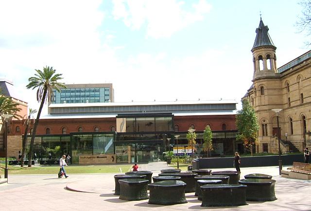
The South Australian Museum is a natural history museum and research institution in Adelaide, South Australia, founded in 1856 and owned by the Government of South Australia. It occupies a complex of buildings on North Terrace in the cultural precinct of the Adelaide Parklands. Plans are under way to move much of its Australian Aboriginal cultural collection, into a new National Gallery for Aboriginal Art and Cultures.
4. Holy Trinity

Trinity Church Adelaide, formerly known as Holy Trinity Church and later Trinity City, is an Australian evangelical Anglican church located at 88 North Terrace in the city of Adelaide, South Australia. Established in 1836, it is one of the earliest churches in the colony of South Australia.
5. Ayers House - National Trust

Ayers House, formerly named Austral House, is the present-day name for a historic mansion on North Terrace, Adelaide, South Australia. It is named after Sir Henry Ayers, five times Premier of South Australia and wealthy industrialist, who occupied it from 1855 until 1897. It is the only mansion on North Terrace to have survived. The house has been listed on the South Australian Heritage Register since July 1980.
6. St. Francis Xavier Cathedral

St Francis Xavier's Cathedral is a Roman Catholic cathedral in Adelaide, South Australia. It is classified as being a Gothic Revival building in the Early English style. The foundation stone was laid in 1856 and the building was dedicated in 1858. The construction of the tower began in 1887; and was not completed until 1996. The tower stands 36 metres (118 ft) high and is 56.5 metres (185 ft) lengthwise and 29.5 metres (97 ft) horizontally.
7. National Wine Centre of Australia

The National Wine Centre of Australia is a public exhibition building about winemaking and its industry in South Australia, opened in 2001. It contains an interactive permanent exhibition of winemaking, introducing visitors to the technology, varieties and styles of wine. It also has a wine tasting area, giving visitors the opportunity to taste and compare wines from different areas of Australia.
8. Botanic Park

Botanic Park, part of Park 11, is a 34 hectare park in the Northeast Parklands of the South Australian capital of Adelaide. The park is bordered by Hackney Road and Frome Road. The University of South Australia, University of Adelaide, and the old Royal Adelaide Hospital are next to this park. The park also abuts the Adelaide Zoo and River Torrens.
9. Elder Park

Elder Park is a public open space in the city of Adelaide, South Australia on the southern bank of the River Torrens and that is bordered by the Adelaide Festival Centre and North Terrace. It is part of Park 26 of the Adelaide Park Lands, and the Torrens Linear Park also passes through Elder Park.
10. Her Majesty's Theatre

Her Majesty's Theatre is a theatre in Adelaide, South Australia, located on Grote Street, originally built in 1913 as the New Tivoli Theatre. Other names through its history have been the Princess Theatre, the Prince of Wales Theatre, Tivoli Theatre and the Opera Theatre.
Share
How likely are you to recommend us?
Disclaimer Please be aware of your surroundings and do not enter private property. We are not liable for any damages that occur during the tours.