38 Sights in (Old) Ottawa, Canada (with Map and Images)
Legend
Premium Sights
Book tickets, guided tours and activities in (Old) Ottawa.
Guided Free Walking Tours
Book free guided walking tours in (Old) Ottawa.
Welcome to your journey through the most beautiful sights in (Old) Ottawa, Canada! Whether you want to discover the city's historical treasures or experience its modern highlights, you'll find everything your heart desires here. Be inspired by our selection and plan your unforgettable adventure in (Old) Ottawa. Dive into the diversity of this fascinating city and discover everything it has to offer.
Sightseeing Tours in (Old) OttawaActivities in (Old) Ottawa
Maman (1999) is a bronze, stainless steel, and marble sculpture in several locations by the artist Louise Bourgeois. The sculpture, which depicts a spider, is among the world's largest, measuring over 30 ft high and over 33 ft wide (9.27 x 8.91 x 10.24 metres). It includes a sac containing 32 marble eggs and its abdomen and thorax are made of rubbed bronze.
2. Sir John A. Macdonald

Sir John Alexander Macdonald was the first prime minister of Canada, serving from 1867 to 1873 and from 1878 until his death in 1891. He was the dominant figure of Canadian Confederation, and had a political career that spanned almost half a century.
3. Rideau Hall

Rideau Hall is the official residence of the governor general of Canada, the representative of the monarch of Canada. Located in Ottawa, the capital of the country on a 36-hectare (88-acre) estate at 1 Sussex Drive. The main building consisting of approximately 175 rooms across 9,500 square metres (102,000 sq ft), and 27 outbuildings around the grounds. Rideau Hall's site lies just outside the centre of Ottawa. It is one of two official vice-regal residences maintained by the federal Crown, the other being the Citadelle of Quebec.
4. Canadian War Museum

The Canadian War Museum (CWM) is a national museum on the country's military history in Ottawa, Ontario, Canada. The museum serves as both an educational facility on Canadian military history and a place of remembrance. The 40,860 square metres (439,800 sq ft) museum building is situated south of the Ottawa River in LeBreton Flats. The museum houses a number of exhibitions and memorials, in addition to a cafeteria, theatre, curatorial and conservation spaces, as well as storage space. The building also houses the Military History Research Centre, the museum's library and archives.
5. National Gallery of Canada

The National Gallery of Canada, located in the capital city of Ottawa, Ontario, is Canada's national art museum. The museum's building takes up 46,621 square metres (501,820 sq ft), with 12,400 square metres (133,000 sq ft) of space used for exhibiting art. It is one of the largest art museums in North America by exhibition space.
6. Lansdowne Park

Lansdowne Park is a 40-acre (16 ha) urban park, historic sports, exhibition and entertainment facility in Ottawa, Ontario, Canada, owned by the City of Ottawa. It is located on Bank Street adjacent to the Rideau Canal in The Glebe neighbourhood of central Ottawa. Lansdowne Park contains the TD Place Stadium and Arena complex, the Aberdeen Pavilion, and the Horticulture Building.
7. Chaudière Falls

The Chaudière Falls, also known as the Kana:tso or Akikodjiwan Falls, are a set of cascades and waterfall in the centre of the Ottawa-Gatineau metropolitan area in Canada where the Ottawa River narrows between a rocky escarpment on both sides of the river. The location is just west of the Chaudière Bridge and Booth-Eddy streets corridor, northwest of the Canadian War Museum at LeBreton Flats and adjacent to the historic industrial E. B. Eddy complex. The islands surrounding the Chaudière Falls, counter-clockwise, are Chaudière Island, Albert Island, little Coffin Island was just south of Albert Island but is now submerged, Victoria Island and Amelia Island,, Philemon Island was originally called the Peninsular Village by the Wrights but became an island when the timber slide was built in 1829 it is now fused to south shore of City of Gatineau, and Russell Island, now submerged, was at the head of the Falls before the Ring dam was built. The falls are about 60 metres (200 ft) wide and drop 15 metres (49 ft). The area around the falls was once heavily industrialized, especially in the 19th century, driving growth of the surrounding cities.
8. Beechwood Cemetery

Beechwood Cemetery is the national cemetery of Canada, located in Vanier, Ottawa, Ontario. Over 82,000 people are buried in the cemetery, including Governor General Ramon Hnatyshyn, Prime Minister Robert Borden, and several members of Parliament, premiers, Canadian Armed Forces personnel and veterans, Royal Canadian Mounted Police personnel, Canadian Security Intelligence Service intelligence officers, and Hockey Hall of Famers, alongside other notable Canadians. In addition to being Canada's national cemetery, it contains the National Military Cemetery of the Canadian Armed Forces and the National Memorial Cemetery of the RCMP.
9. Canadian Museum of Science and Technology
The Canada Science and Technology Museum is a national museum of science and technology in Ottawa, Ontario, Canada. The museum has a mandate to preserve and promote the country's scientific and technological heritage. The museum is housed in a 13,458 square metres (144,860 sq ft) building. The museum is operated by Ingenium, a Crown corporation that also operates two other national museums of Canada.
Wikipedia: Canada Science and Technology Museum (EN), Website, Opening Hours
10. Kìwekì Point
The National Capital Commission is the Crown corporation responsible for development, urban planning, and conservation in Canada's Capital Region, including administering most lands and buildings owned by the Government of Canada in the region.
11. Christ Church Cathedral

Christ Church Cathedral is the Anglican cathedral in Ottawa, Ontario, Canada. The church is located at 414 Sparks Street in the northwest section of the city's downtown at the western end of Sparks Street on top of a promontory looking down to the Ottawa River.
12. Aberdeen Pavilion

The Aberdeen Pavilion is an exhibition hall in Ottawa, Ontario, Canada. Overlooking the Rideau Canal, it is located in Lansdowne Park, Ottawa's historic fairgrounds. For many years, the building was known as the "Cattle Castle", due to its use for the Central Canada Exhibition's agricultural exhibits and shows. It is the last surviving Canadian example of what was once a common form of Victorian exhibition hall, and was designated a National Historic Site of Canada in 1983.
13. Central Experimental Farm

The Central Experimental Farm (CEF), commonly known as the Experimental Farm, is an agricultural facility, working farm, and research centre of the Science and Technology Branch, formerly the Research Branch, of Agriculture and Agri-Food Canada. As the name indicates, this farm is centrally located in and now surrounded by the City of Ottawa, Ontario, Canada. Located on 4 square kilometres (1.5 sq mi) of land, the farm is a National Historic Site of Canada and most buildings are protected and preserved as heritage buildings.
14. Confederation Park

Confederation Park (French: Parc de la Confédération) is a public park and National Historic Site of Canada, located in the downtown core of Ottawa, Ontario, Canada. It is bordered on the south by Laurier Avenue and Ottawa City Hall; on the east by the Rideau Canal and National Defence Headquarters; on the north by the Mackenzie King Bridge, the Rideau Centre and the National Arts Centre; and to the west by Elgin Street and the Lord Elgin Hotel.
15. Canada Agriculture and Food Museum

The Canada Agriculture and Food Museum is a national agricultural museum in Ottawa, Ontario, Canada. Occupying several buildings within the Central Experimental Farm, the museum operates as a "working farm", and provides public programs and exhibitions on agriculture sciences, and on the history of agriculture in Canada. In addition to the exhibitions held on the grounds, the museum also organizes travelling exhibitions for other museums across the country.
16. Palmer House

James William Strutt was a Canadian architect. Practising between 1950 and 1999 and working primarily in the Ottawa area, Strutt is noted for his role in the development of modern architecture in Canada following World War II.
17. National Holocaust Monument

The National Holocaust Monument is a Holocaust memorial in Ottawa, Ontario, across from the Canadian War Museum at the northeast corner of Wellington and Booth Streets, and about 1.5 km away from Parliament Hill. The memorial was designed by Daniel Libeskind.
18. Garden of the Provinces and Territories

The Garden of the Provinces and Territories is a 4-acre (1.6 ha) site along Confederation Boulevard in Ottawa, Ontario, Canada's capital city. It is bounded by the Sparks Street escarpment on the south, Wellington Street on the west and north, and Bay Street to the east between Christ Church Cathedral and the Library and Archives Canada. It was officially opened on September 25, 1962, as a western gateway to the Parliament Buildings. The park was renamed from "Garden of the Provinces" on October 6, 2005 to recognize and include Canada's three territories. Scott Brison, then the Minister of Public Works and Government Services Canada, officially renamed the park.
19. Centretown United Church

Centretown United Church is an historic church located in Ottawa, Ontario, Canada at 507 Bank Street at Argyle in the Centretown area. It was built in 1906 as the Stewarton Presbyterian Church using Gothic Revival architecture under the architecture of Moses Chamberlain Edey, (designer of Heritage site the Aberdeen Pavilion and the Daly Building. The corner stone was laid by Sir Mortimer Clarke, Lieutenant Governor of Ontario. Centretown United Church is a member church of the United Church of Canada.
20. St. Bartholomew's Church

St. Bartholomew's Anglican Church is a place of worship in Ottawa, Ontario, Canada. The building was constructed in the latter half of the 19th century and serves the surrounding neighbourhoods. Additionally, St. Bartholomew's is, due to its location next to Rideau Hall, the place of worship for various Governors General of Canada and some members of the Canadian Royal Family. It is also the regimental chapel of the Governor General's Foot Guards.
21. Blessed Sacrament Catholic Church

Blessed Sacrament Catholic Church is a Catholic church in the Glebe neighbourhood of Ottawa, Ontario, Canada. The parish was founded on March 25, 1913, with the first building being a simple chapel. The current building at 194 Fourth Avenue, was built in 1931.
Wikipedia: Blessed Sacrament Catholic Church (Ottawa) (EN), Website
22. Earnscliffe

Earnscliffe is a Victorian manor in Ottawa, Ontario, built in the Gothic Revival style. During the late 19th century, it was home to Canada's first Prime Minister, Sir John A. Macdonald. Since 1930, it has served as the residence of the British High Commissioner to Canada.
23. Peacekeeping Monument

Reconciliation: The Peacekeeping Monument is a monument in Ottawa, the capital of Canada, commemorating Canada's role in international peacekeeping and the soldiers who have participated and are currently participating, both living and dead.
24. Dominion Arboretum

The Dominion Arboretum is an arboretum part of the Central Experimental Farm of Agriculture and Agri-Food Canada in Ottawa, Ontario, Canada. Originally begun in 1889, the Arboretum covers about 26 hectares of rolling land between Prince of Wales Drive, Dow's Lake and the Rideau Canal. Carleton University is located at the opposite side of the Canal. At a latitude of 45°, it can experience extremely hot and humid summers and extremely cold winters.
25. Dominion Observatory

The Dominion Observatory was an astronomical observatory in Ottawa, Ontario that operated from 1902 to 1970. The Observatory was also an institution within the Canadian Federal Government. The observatory grew out of the Department of the Interior's need for the precise coordinates and timekeeping that at that time could only come from an observatory. For several years they had used a small observatory on the Ottawa River for this purpose. In 1902, it was decided that Canada needed a larger national observatory similar to the Royal Greenwich Observatory in Britain.
26. St. Peter's Evangelical Lutheran Church

St. Peter's Evangelical Lutheran Church is a church in Ottawa, Ontario, Canada situated on Ottawa's ceremonial route and overlooks the Garden of the Provinces, the Ottawa River and the Gatineau Hills. St. Peter's is an Ottawa landmark. The motto is "A community of faith seeking to grow in God's grace and love".
Wikipedia: St. Peter's Lutheran Church (Ottawa) (EN), Website
27. Canadian Tribute to Human Rights
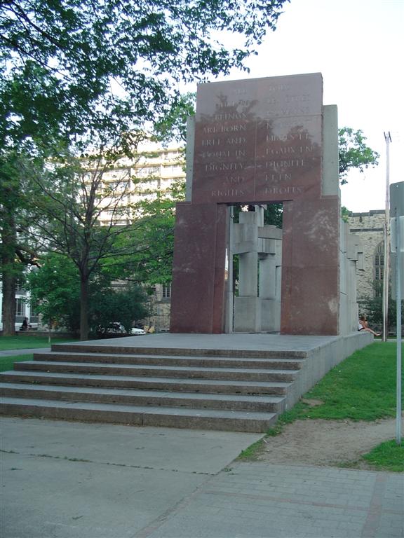
The Canadian Tribute to Human Rights, also known as the Human Rights Monument, is a monumental sculpture located at the corner of Lisgar and Elgin streets in Ottawa, Ontario, Canada. It was designed by Montreal artist and architect Melvin Charney and unveiled by Tenzin Gyatso, the fourteenth Dalai Lama, on September 30, 1990.
28. Billings Estate Museum

The Billings Estate National Historic Site is a heritage museum in Ottawa, Ontario, Canada. It is located at 2100 Cabot St. in the former home of one of the region's earliest settlers. The oldest wood-framed house in Ottawa was built in 1827-9 by Massachusetts-born Braddish Billings. It became the home for the following four generations of the Billings family. It is Ottawa's oldest surviving house, though the Bytown Museum building is older. Billings had moved to the area in 1812, and was the first settler in Gloucester Township.
29. Rideau Falls

The Rideau Falls are two 11-metre waterfalls located in Ottawa, Ontario, Canada, where the Rideau River empties into the Ottawa River. The falls are divided by Green Island, with Ottawa's Old City Hall just to the south. To the west of the falls is the headquarters of the National Research Council while to the east are the Canada and the World Pavilion and the French Embassy. Samuel de Champlain described the falls as "...a marvelous fall...it descends a height of twenty or twenty-five fathoms with such impetuosity that it makes an arch nearly four hundred paces broad." The falls were named by the early French for their resemblance to a curtain, or rideau in French. The Rideau River was later named after the falls. The Rideau Canal was constructed to bypass these falls and the Hog's Back Falls.
30. MacKay United Church

MacKay United Church is a United Church of Canada church in the New Edinburgh neighbourhood of Ottawa, Ontario, Canada. The church is located at the intersection of 39 Dufferin and Mackay at the southwest corner of the Rideau Hall estate. MacKay's present minister is Reverend Peter Woods.
31. Ottawa Chinatown Arch

Ottawa's Chinatown is located along Somerset Street west of downtown Ottawa. It runs from Bay Street in the east to Preston Street in the west. Signs for Chinatown continue along Somerset until Preston Street, and Chinese/Asian restaurants can be found even farther west.
32. Maplelawn Historic Garden

Maplelawn is an historic house and former estate located in Ottawa, Ontario, Canada. The house was built between 1831 and 1834 as the centre of a farming estate by the Thomson family. In 1877 the Cole family bought the estate and lived there until 1989. The house is now owned by the National Capital Commission and it is a designated national historic site. It is particularly noted for the well preserved and rare walled garden next to the house, The Maplelawn Garden. Since 1999 the Maplelawn has been the location of the Keg Manor restaurant. Today the house is located in Westboro at 529 Richmond Road.
33. Monument to Canadian Aid Workers

The Monument to Canadian Aid Workers is a monument in Ottawa, Ontario, Canada. It is dedicated to Canadian aid workers who have lost their lives during foreign deployments. As a monument, it is internationally unique in its form and purpose.
34. National Arts Centre

The National Arts Centre (NAC) is a Canadian centre for the performing arts located in Ottawa, Ontario, along the Rideau Canal. It is operated by the eponymous performing arts organisation National Arts Centre. The National Arts Centre was designated a National Historic Site of Canada in 2006.
Wikipedia: National Arts Centre (building) (EN), Website, Heritage Website
35. Notre-Dame Cathedral Basilica

The Notre-Dame Cathedral Basilica is a Roman Catholic minor basilica in Ottawa, Ontario, Canada located on 385 Sussex Drive in the Lower Town neighbourhood. It was designated a National Historic Site of Canada in 1990.
Wikipedia: Notre-Dame Cathedral Basilica (Ottawa) (EN), Website, Heritage Website
36. St. Patrick's Basilica

St Patrick's Basilica is a Roman Catholic Church in Ottawa, Ontario, Canada. Located at 281 Nepean Street in Downtown Ottawa, it is the oldest church in the city that serves the English-speaking community. The Basilica is one of the regular buildings featured in the Doors Open Ottawa architectural heritage day.
37. Bank of Canada Museum

The Bank of Canada Museum, formerly known as the Currency Museum, opened in 1980 on the ground floor of the Bank of Canada building in Ottawa, Ontario. Temporarily closed in 2013 for major building renovations, the museum reopened in a new space on July 1, 2017, in a new building, with a completely new design and concept. It is, however, connected to the main building through the Bank of Canada's underground conference centre.
38. Princess Patricia's Canadian Light Infantry Memorial

Princess Patricia's Canadian Light Infantry is one of the three Regular Force infantry regiments of the Canadian Army of the Canadian Armed Forces. Formed in 1914, it is named for Princess Patricia of Connaught, daughter of the then-Governor General of Canada. The regiment is composed of three battalions, for a total of 2,000 soldiers. The PPCLI is the main lodger unit of Canadian Forces Base (CFB) Edmonton in Alberta and CFB Shilo in Manitoba, and attached to 3rd Canadian Division; as such, it serves as the "local" regular infantry regiment for much of Western Canada. The Loyal Edmonton Regiment (LER), a Reserve Force battalion, is affiliated with the PPCLI but is not formally part of it. As part of this affiliation, the LER carries the designation '4th Battalion, Princess Patricia's Canadian Light Infantry'.
Share
How likely are you to recommend us?
Disclaimer Please be aware of your surroundings and do not enter private property. We are not liable for any damages that occur during the tours.