100 Sights in New York, United States (with Map and Images)
Legend
Explore interesting sights in New York, United States. Click on a marker on the map to view details about it. Underneath is an overview of the sights with images. A total of 100 sights are available in New York, United States.
Sightseeing Tours in New YorkActivities in New York
Little Island at Pier 55 is an artificial island park in the Hudson River west of Manhattan in New York City, adjoining Hudson River Park. Designed by Heatherwick Studio, it is near the intersection of West Street and West 13th Street in the Meatpacking District and Chelsea neighborhoods of Manhattan. It is located slightly west of the Manhattan shoreline atop Hudson River Pier 55, connected to Hudson River Park in Manhattan by footbridges at 13th and 14th Streets. Little Island has two concession stands, a small stage, and a 687-seat amphitheater.

Bryant Park is a 9.6-acre (39,000 m2) public park located in the New York City borough of Manhattan. Privately managed, it is located between Fifth Avenue and Avenue of the Americas and between 40th and 42nd Streets in Midtown Manhattan. The eastern half of Bryant Park is occupied by the Main Branch of the New York Public Library. The western half, which contains a lawn, shaded walkways, and amenities such as a carousel, is located entirely over an underground structure that houses the library's stacks. The park hosts several events, including a seasonal "Winter Village" with an ice rink and shops during the winter.
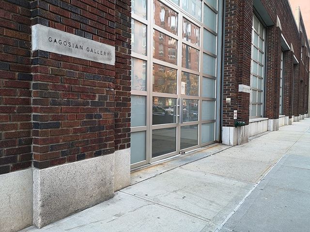
The Gagosian Gallery is a contemporary art gallery owned and directed by Larry Gagosian. The gallery exhibits some of the most influential artists of the 20th and 21st centuries. There are 18 gallery spaces – six in New York City, two in London, three in Paris, and one each in Basel, Gstaad, Beverly Hills, Rome, Athens, Geneva and Hong Kong.

Central Park is an urban park between the Upper West Side and Upper East Side neighborhoods of Manhattan in New York City that was the first landscaped park in the United States. It is the sixth-largest park in the city, containing 843 acres (341 ha), and the most visited urban park in the United States, with an estimated 42 million visitors annually as of 2016.

The Parachute Jump is a defunct amusement ride and a landmark in the New York City borough of Brooklyn, along the Riegelmann Boardwalk at Coney Island. Situated in Steeplechase Plaza near the B&B Carousell, the structure consists of a 250-foot-tall (76 m), 170-short-ton (150 t) open-frame, steel parachute tower. Twelve cantilever steel arms radiate from the top of the tower; when the ride was in operation, each arm supported a parachute attached to a lift rope and a set of guide cables. Riders were belted into a two-person canvas seat, lifted to the top, and dropped. The parachute and shock absorbers at the bottom would slow their descent.

The Wonder Wheel is a 150-foot-tall (46 m) eccentric Ferris wheel at Deno's Wonder Wheel Amusement Park at Coney Island in the New York City borough of Brooklyn. The wheel is located on a plot bounded by West 12th Street to the west, Bowery Street to the north, Luna Park to the east, and the Riegelmann Boardwalk to the south. As with other eccentric Ferris wheels, some of the Wonder Wheel's passenger cabins are not fixed directly to the rim of the wheel, but instead slide along winding sets of rails between the hub and the rim.

The Empire State Building is a 102-story Art Deco skyscraper in the Midtown South neighborhood of Manhattan in New York City. The building was designed by Shreve, Lamb & Harmon and built from 1930 to 1931. Its name is derived from "Empire State", the nickname of the state of New York. The building has a roof height of 1,250 feet (380 m) and stands a total of 1,454 feet (443.2 m) tall, including its antenna. The Empire State Building was the world's tallest building until the first tower of the World Trade Center was topped out in 1970; following the September 11 attacks in 2001, the Empire State Building was New York City's tallest building until it was surpassed in 2012 by One World Trade Center. As of 2022, the building is the seventh-tallest building in New York City, the ninth-tallest completed skyscraper in the United States, and the 54th-tallest in the world.

George Washington is an outdoor sculpture by Henry Kirke Brown (1814–1886), located in Union Square, Manhattan, in the United States. The bronze equestrian statue was dedicated in 1856 and is the oldest sculpture in the New York City Parks collection. It depicts Washington beginning his triumphant march of the Continental Army through Manhattan on Evacuation Day, November 25, 1783, soon after the British Army had departed New York City.
Wikipedia: Equestrian statue of George Washington (New York City) (EN)

The City Hall station, also known as City Hall Loop station, is a closed station on the IRT Lexington Avenue Line of the New York City Subway. It is located under City Hall Park, next to New York City Hall, in the Civic Center neighborhood of Manhattan in New York City. The station was constructed for the Interborough Rapid Transit Company (IRT) as the southern terminal of the city's first subway line, which was approved in 1900. Construction of the segment of the line that includes the City Hall station started on September 12 of the same year. The station opened on October 27, 1904, as one of the original 28 stations of the New York City Subway. As ridership grew, it was deemed infeasible to lengthen the original platform to accommodate ten-car trains. The station was closed on December 31, 1945, because of its proximity to the Brooklyn Bridge station.
Wikipedia: City Hall station (IRT Lexington Avenue Line) (EN)

The Brooklyn Bridge is a hybrid cable-stayed/suspension bridge in New York City, spanning the East River between the boroughs of Manhattan and Brooklyn. Opened on May 24, 1883, the Brooklyn Bridge was the first fixed crossing of the East River. It was also the longest suspension bridge in the world at the time of its opening, with a main span of 1,595.5 feet (486.3 m) and a deck 127 ft (38.7 m) above mean high water. The span was originally called the New York and Brooklyn Bridge or the East River Bridge but was officially renamed the Brooklyn Bridge in 1915.

The Apollo Theater is a multi-use theater at 253 West 125th Street in the Harlem neighborhood of Upper Manhattan in New York City. It is a popular venue for black American performers and is the home of the TV show Showtime at the Apollo. The theater, which has approximately 1,500 seats across three levels, was designed by George Keister with elements of the neoclassical style. The facade and interior of the theater are New York City designated landmarks and are listed on the National Register of Historic Places. The nonprofit Apollo Theater Foundation (ATF) operates the theater, as well as two smaller auditoriums at the Victoria Theater and a recording studio at the Apollo.

Four Continents is the collective name of four sculptures by Daniel Chester French, installed outside the Alexander Hamilton U.S. Custom House at Bowling Green in Manhattan, New York City. French performed the commissions with associate Adolph A. Weinman.
13. Gay Street

Gay Street is a short, angled street that marks off one block of Greenwich Village in the New York City borough of Manhattan. Although coincidentally encompassed by the Stonewall National Monument, the street's name does not refer to the LGBT character of Greenwich Village, or to any other LGBT commemoration. Rather, the name may come from a family named Gay who owned land or lived there in colonial times: a newspaper of May 11, 1775, contains a classified ad where an "R. Gay", living in the Bowery, offers a gelding for sale.This street, originally a stable alley, was probably named for an early landowner, not for the sexuality of any denizens, who coincidentally reside in Greenwich Village, a predominantly homosexual community. Nor is it likely, as is sometimes claimed, that its namesake was Sidney Howard Gay, editor of the National Anti-Slavery Standard; he would have been 19 when the street was christened in 1833. The mistaken association with an abolitionist is probably because the street's residents were mainly black, many of them servants of the wealthy white families on Washington Square. Later it became noted as an address for black musicians, giving the street a bohemian reputation.
14. Church of Saint Ignatius Loyola

The Church of St. Ignatius of Loyola is a Catholic parish church located on the Upper East Side of Manhattan, New York City, administered by the Society of Jesus (Jesuits). The parish is under the authority of the Archdiocese of New York, and was established in 1851 as St. Lawrence O'Toole's Church. In 1898, permission to change the patron saint of the parish from St. Lawrence O'Toole to St. Ignatius of Loyola was granted by Rome. The address is 980 Park Avenue, New York City, New York 10028. The church on the southwest corner of Park Avenue and 84th Street is part of a Jesuit complex on the block that includes Wallace Hall, the parish hall beneath the church, the rectory at the midblock location on Park Avenue, the grade school of St. Ignatius's School on the north midblock location of 84th Street behind the church and the high school of Loyola School at the northwest corner of Park Avenue and 83rd Street. In addition, another Jesuit high school, Regis High School, occupies the midblock location on the north side of 84th Street. The church was added to the National Register of Historic Places on July 24, 1980.
Wikipedia: Church of St. Ignatius Loyola (New York City) (EN)
15. Bailey Fountain

- You are free: to share – to copy, distribute and transmit the work to remix – to adapt the work
- Under the following conditions: attribution – You must give appropriate credit, provide a link to the license, and indicate if changes were made. You may do so in any reasonable manner, but not in any way that suggests the licensor endorses you or your use. share alike – If you remix, transform, or build upon the material, you must distribute your contributions under the same or compatible license as the original.
Bailey Fountain is an outdoor sculpture in New York City at the site of three 19th century fountains in Grand Army Plaza, Brooklyn, New York, United States. Renovated in 1956 and 2005-06, the 1932 fountain was funded by philanthropist Frank Bailey as a memorial to his wife Mary Louise Bailey. After 1974 thefts, some sculpture elements were stored for safekeeping. The bronze Art Deco design of the Bailey Fountain consists of six monumental figures beginning with the top two, a man representing Wisdom with his left hand on the tiller steering the ship of Life and a woman representing Felicity with her right hand holding a cornucopia. Below them are two other statues, one a chubby standing child helping to shoulder that cornucopia while the second is a laughing Greek mythological figure called Nereus who is the eldest son of Pontus the Sea and Gaia the Earth. To the sides of the fountain are the two remaining aquatic Nereides / sea nymph figures with upper torsos emerging from the water their heads back trumpeting with conch shells as their fish tails twist in the background.
16. Teardrop Park

- You are free: to share – to copy, distribute and transmit the work to remix – to adapt the work
- Under the following conditions: attribution – You must give appropriate credit, provide a link to the license, and indicate if changes were made. You may do so in any reasonable manner, but not in any way that suggests the licensor endorses you or your use. share alike – If you remix, transform, or build upon the material, you must distribute your contributions under the same or compatible license as the original.
Teardrop Park is a 1.8-acre (0.7 ha) public park in lower Manhattan, in Battery Park City, near the site of the World Trade Center. It was designed by Michael Van Valkenburgh Associates, a New York City landscape architecture firm. The park includes art designed for it by Ann Hamilton. The park sits between residential buildings toward the north end of Battery Park City at the corner of Warren Street and River Terrace. The creation of Teardrop Park is part of the ongoing construction of Battery Park City, a neighborhood on the southwest edge of Manhattan Island that was created in the 1970s by landfilling the Hudson River between the existing bulkhead and the historic pierhead line. Before construction, the site was empty and flat. The park was designed in anticipation of four high residential towers that would define its eastern and western edges. Although Teardrop Park is a New York City public park, the client for the park was the Battery Park City Authority, and maintenance is overseen by the Battery Park City Parks Conservancy.
17. Cathedral of Allen African Methodist Episcopal Church

The Greater Allen Cathedral of New York is an African Methodist Episcopal church located in Jamaica, Queens, New York. The congregation currently has over 24,500 members, making it one of the largest churches in the United States. Its annual budget exceeds $72 million. GAC once operated a 750-student private school, Additionally, the church offers numerous commercial and social service enterprises. Allen holds a number of expansive commercial and residential properties and coordinates a number of subsidiary organizations. GAC has been named one of the nation's most productive religious and urban development institutions, and is one of the Borough of Queens largest employers. The church has been pastored by Floyd Flake and his wife Elaine for nearly five decades. Floyd Flake also served as the president of Wilberforce University-- his alma mater and a former United States Congressman. Flake's wife, M. Elaine Flake was appointed by Bishop Gregory Ingram to serve as senior Pastor when Floyd Flake retired in 2020.
Wikipedia: Greater Allen A. M. E. Cathedral of New York (EN), Website
18. Jacques Marchais Museum of Tibetan Art

The Jacques Marchais Museum of Tibetan Art is a museum located on the residential Lighthouse Hill in Egbertville, Staten Island, New York City. It is home to one of the United States' most extensive collections of Himalayan artifacts. The museum was created by Jacques Marchais, (1887-1948) an American woman, to serve as a bridge between the West and the rich ancient and cultural traditions of Tibet and the Himalayan region. Marchais designed her educational center to be an all-encompassing experience: it was built to resemble a rustic Himalayan monastery with extensive terraced gardens and grounds and a fish and lotus pond. The museum was praised for its authenticity by the Dalai Lama, who visited in 1991. In 2009, the site was listed on the New York State Register and National Register of Historic Places. A writer in the New York Times referred to the museum's founder under the name Jacqueline Klauber, noting that she used Marchais as her professional name.
Wikipedia: Jacques Marchais Museum of Tibetan Art (EN), Website
19. Leslie-Lohman Museum of Art

The Leslie-Lohman Museum of Art (LLMA), formerly the Leslie-Lohman Museum of Gay and Lesbian Art, is a visual art museum in SoHo, Lower Manhattan, New York City. It mainly collects, preserves and exhibits visual arts created by LGBTQ artists or art about LGBTQ+ themes, issues, and people. The museum, operated by the Leslie-Lohman Gay Art Foundation, offers exhibitions year-round in numerous locations and owns more than 22,000 objects, including, paintings, drawings, photography, prints and sculpture. It has been recognized as one of the oldest arts groups engaged in the collection and preservation of gay art. The foundation was awarded Museum status by the New York State Board of Regents in 2011 and was formally accredited as a museum in 2016. The museum is a member of the American Alliance of Museums and operates pursuant to their guidelines. As of 2019, the LLMA was the only museum in the world dedicated to artwork documenting the LGBTQ experience.
20. The Met Cloisters

The Cloisters, also known as the Met Cloisters, is a museum in the Washington Heights neighborhood of Upper Manhattan, New York City. The museum, situated in Fort Tryon Park, specializes in European medieval art and architecture, with a focus on the Romanesque and Gothic periods. Governed by the Metropolitan Museum of Art, it contains a large collection of medieval artworks shown in the architectural settings of French monasteries and abbeys. Its buildings are centered around four cloisters—the Cuxa, Saint-Guilhem, Bonnefont and Trie—that were acquired by American sculptor and art dealer George Grey Barnard in France before 1913, and moved to New York. Barnard's collection was bought for the museum by financier and philanthropist John D. Rockefeller Jr. Other major sources of objects were the collections of J. P. Morgan and Joseph Brummer.
21. Center for Brooklyn History

The Center for Brooklyn History is a museum, library, and educational center founded in 1863 that preserves and encourages the study of Brooklyn's 400-year history. The center's Romanesque Revival building, located at Pierrepont and Clinton Streets in Brooklyn Heights, was designed by George B. Post and built in 1878–1881 by David H. King Jr., is a National Historic Landmark and part of New York City's Brooklyn Heights Historic District. The CBH houses materials relating to the history of Brooklyn and its people, and hosts exhibitions which draw over 9,000 members a year. In addition to general programming, the CBH serves over 70,000 public school students and teachers annually by providing exhibit tours, educational programs and curricula, and making its professional staff available for instruction and consultation.
22. Brooklyn Bridge Park

Brooklyn Bridge Park is an 85-acre (34 ha) park on the Brooklyn side of the East River in New York City. Designed by landscape architecture firm Michael Van Valkenburgh Associates, the park is located on a 1.3-mile (2.1 km) plot of land from Atlantic Avenue in the south, under the Brooklyn Heights Promenade and past the Brooklyn Bridge, to Jay Street north of the Manhattan Bridge. From north to south, the park includes the preexisting Empire–Fulton Ferry and Main Street Parks; the historic Fulton Ferry Landing; and Piers 1–6, which contain various playgrounds and residential developments. The park also includes Empire Stores and the Tobacco Warehouse, two 19th-century structures, and is a part of the Brooklyn Waterfront Greenway, a series of parks and bike paths around Brooklyn.
23. Lewis Howard Latimer House Museum

The Lewis H. Latimer House, also called the Latimer House or the Lewis Latimer House, is a historic house located at 34-41 137th Street in Flushing, Queens, New York City. It was constructed in the Queen Anne style of architecture between 1887 and 1889 by the Sexton family. It served as the home of the African-American inventor Lewis Howard Latimer from 1903 to 1928, and is now operated as a museum dedicated to the inventor's work. In addition, this museum-house also illuminated the life and achievements of other black scientists. The house remained property of the Latimer family until 1963. Currently, the Lewis H. Latimer House is owned by the New York City Department of Parks and Recreation, operated by the Lewis H. Latimer Fund, Inc., and is a member of the Historic House Trust.
24. Hostelling International New York City

The Association Residence Nursing Home, also called the Association for the Relief of Respectable, Aged and Indigent Females, is a historic building in New York City built from 1881–1883 to the design of Richard Morris Hunt in the Victorian Gothic style. It is located on Amsterdam Avenue between 103rd and 104th Streets on the Upper West Side of Manhattan, and is now a hostel run by Hostelling International. The Association was founded in 1814 to help the widows of soldiers of the American Revolutionary War and the War of 1812. An addition to the building was constructed on the south end of the property in 1907, with seven Tiffany windows that are now in the Morse Museum of American Art's collection. The building was placed on the National Register of Historic Places in 1975.
25. Cooper–Hewitt, Smithsonian Design Museum
Cooper Hewitt, Smithsonian Design Museum is a design museum housed within the Andrew Carnegie Mansion in Manhattan, New York City, along the Upper East Side's Museum Mile. It is one of 19 museums that operate within the Smithsonian Institution and is one of three Smithsonian facilities located in New York City, the other two being the National Museum of the American Indian's George Gustav Heye Center in Bowling Green and the Archives of American Art New York Research Center in the Flatiron District. Unlike other Smithsonian museums, Cooper Hewitt charges an admissions fee. It is the only museum in the United States devoted to historical and contemporary design. Its collections and exhibitions explore design aesthetic and creativity from throughout the United States' history.
Wikipedia: Cooper–Hewitt, National Design Museum (EN), Website
26. Colonnade row

Colonnade Row, also known as LaGrange Terrace, is a group of 1830s row houses on present-day Lafayette Street in the NoHo neighborhood of Manhattan in New York City. They are believed to have been built by Seth Geer, although the project has been attributed to a number of other architects. The buildings' original name comes from the Marquis de Lafayette's estate in France, but the series of nine row houses, of which four remain, owe their existence to John Jacob Astor, who bought the property and whose grandson John Jacob Astor III later lived at No. 424. The remaining buildings are New York City designated landmarks and listed on the National Register of Historic Places under the name LaGrange Terrace. The facades remain standing on Lafayette Street south of Astor Place.
27. Music Hall

The Snug Harbor Music Hall on the grounds of Sailors' Snug Harbor in the New Brighton neighborhood of Staten Island is a 686-seat Greek Revival auditorium that opened in July 1892, making it the second-oldest music hall in New York City. It was designed by the English immigrant architect Robert W. Gibson. Its inaugural performance was the cantata, "The Rose Maiden." In attendance were around 600 residents in plain wooden seats and 300 trustees with their guests in upholstered balcony seats. Entertainment in the decades that followed included the Georgia Minstrels and the Boston Ladies Schubert Quartet. It added film screenings in 1911 and sound projection in 1930. The building closed sometime in the 1970s when the campus faced a lack of funds and a decline in residents.
28. Cleopatra's Needle

Cleopatra's Needle in New York City is one of a pair of obelisks, together named Cleopatra's Needles, that were moved from the ruins of the Caesareum of Alexandria, Egypt, in the 19th century. The stele, dating from the 15th century B.C., was installed in Central Park, west of the Metropolitan Museum of Art's main building in Manhattan, on February 22, 1881. It was secured in May 1877 by judge Elbert E. Farman, the United States Consul General at Cairo, as a gift from the Khedive for the United States remaining a friendly neutral as two European powers, France and Britain, maneuvered for political control of the Egyptian government. The transportation costs were largely paid by a railroad magnate, William Henry Vanderbilt, the eldest son of Cornelius Vanderbilt.
Wikipedia: Cleopatra's Needle (New York City) (EN), Website, Website Alternate
29. Williamsburg Houses

The Williamsburg Houses, originally called the Ten Eyck Houses, is a public housing complex built and operated by the New York City Housing Authority (NYCHA), in the Williamsburg neighborhood of Brooklyn. It consists of 20 buildings on a site bordered by Scholes, Maujer, and Leonard Streets and Bushwick Avenue. The Williamsburg Houses were built in 1936–1938 under the auspices of the Housing Division of the Public Works Administration (PWA). Richmond Shreve was the chief architect of the project; the design team of nine other architects was led by the Swiss-American modernist William Lescaze. The construction contract was awarded to Starrett Brothers & Eken. The designs called for the inclusion of modern art commissioned through the Federal Arts Project.
30. Comedy Cellar

The Comedy Cellar is a comedy club in Manhattan where many top New York comedians perform, sometimes referred to as the "Harvard of comedy clubs". It was founded in 1982 by then stand-up comedian, and current television writer/producer Bill Grundfest. It is located in Greenwich Village on 117 MacDougal Street between West 3rd Street and Minetta Lane. Above the club is a restaurant called The Olive Tree Cafe to which it is connected, where many of the comedians hang out after performing. The club is owned by Noam Dworman, who inherited it from his late father Manny in 2003. It is being booked by Estee Adoram, who has developed the club's talent for nearly four decades. The businesses share the same menu, kitchen, and staff as the Olive Tree Cafe.
31. Inwood Hill Park

Inwood Hill Park is a 196 acres (79 ha) public park in the Inwood neighborhood of Manhattan, New York City, operated by the New York City Department of Parks and Recreation. On a high schist ridge that rises 200 feet (61 m) above the Hudson River from Dyckman Street to the northern tip of the island, Inwood Hill Park's densely folded, glacially scoured topography contains the largest remaining old-growth forest on the island of Manhattan. The area is also known as the Shorakapkok Preserve, shorakapkok meaning 'the sitting place' in the Munsee language used by the Wecquaesgeek tribe who inhabited the area for nearly 700 years. Unlike other Manhattan parks, Inwood Hill Park is largely natural and consists of mostly wooded, non-landscaped hills.
32. Coney Island Yard Electric Motor Repair Shop

The New York City Transit Authority operates a total of 24 rail yards for the New York City Subway system, and one for the Staten Island Railway. There are 10 active A Division yards and 11 active B Division yards, two of which are shared between divisions for storage and car washing. In addition, there is one yard for the Staten Island Railway and three non-revenue Division-independent yards. Many of the system's yards are used for off-peak storage, whereas some have inspection facilities where basic routine maintenance is carried out. Of these yards, rolling stock are assigned to seven A Division yards and seven B Division yards. Within the yards are 14 maintenance facilities, whereas two yards perform major overhaul and car rebuilding work.
Wikipedia: Coney Island Yard Electric Motor Repair Shop (EN)
33. John V. Lindsay East River Park

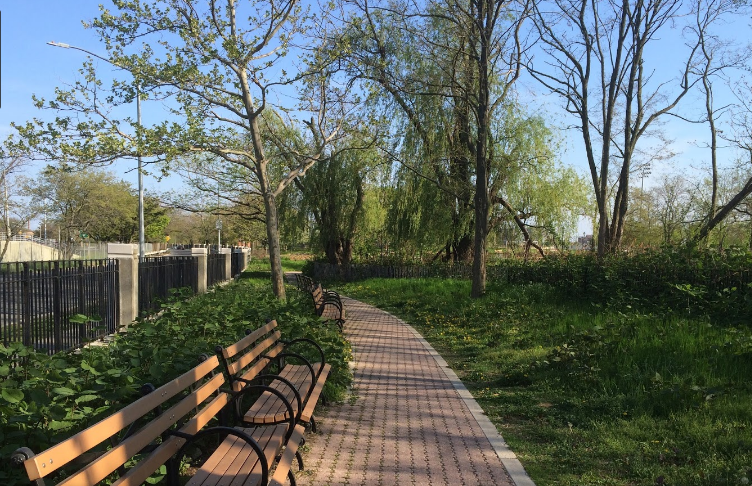
East River Park, also called John V. Lindsay East River Park, is 57.5-acre (20 ha) public park located on the Lower East Side of Manhattan, administered by the New York City Department of Parks and Recreation. Bisected by the Williamsburg Bridge, it stretches along the East River from Montgomery Street up to 12th Street on the east side of the FDR Drive. Its now-demolished amphitheater, built in 1941 just south of Grand Street, had been reconstructed and was often used for public performances. The park includes football, baseball, and soccer fields; tennis, basketball, and handball courts; a running track; and bike paths, including the East River Greenway, all of which are to be demolished. Fishing is another popular activity, for now.
34. Flatiron Building

The Flatiron Building, originally the Fuller Building, is a triangular 22-story, 285-foot-tall (86.9 m) steel-framed landmarked building at 175 Fifth Avenue in the eponymous Flatiron District neighborhood of the borough of Manhattan in New York City. Designed by Daniel Burnham and Frederick P. Dinkelberg, and known in its early days as "Burnham's Folly", it was completed in 1902 and originally included 20 floors. The building sits on a triangular block formed by Fifth Avenue, Broadway, and East 22nd Street—where the building's 87-foot (27 m) back end is located—with East 23rd Street grazing the triangle's northern (uptown) peak. The name "Flatiron" derives from its triangular shape, which recalls that of a cast-iron clothes iron.
35. Church of St. Vincent Ferrer

The Church of St. Vincent Ferrer is a Roman Catholic parish in the Upper East Side of Manhattan, New York City. It was built in 1918 by the Dominicans; the attached priory serves as the headquarters of the Eastern United States Province of the order. Its architecture has some unusual features: above the front entrance is one of the few statues of the Crucifixion on the exterior of an American Catholic church; and inside, the Stations of the Cross depict Christ with oil paintings instead of statuary or carvings. It has two Schantz pipe organs. The church building, at the corner of Lexington Avenue and East 66th Street in the Lenox Hill section of the Upper East Side, has been called "one of New York's greatest architectural adornments."
36. Voorlezer's House
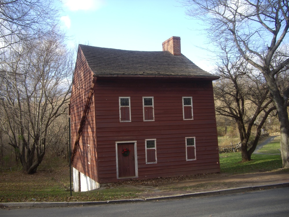
The Voorlezer's House is a historic clapboard frame house in Historic Richmond Town in Staten Island, New York. It is widely believed to be the oldest known schoolhouse in what is now the United States, although the sole inhabitant to hold the title of voorlezer, Hendrick Kroesen, only lived on the property from 1696 until 1701. The present structure became a private residence for more than a century and is now owned and operated by the Staten Island Historical Society. Despite being traditionally dated to before 1696 and sitting on land patented in 1680, it is more likely to have been constructed in the mid-eighteenth century, probably in the 1760s by Jacob Rezeau, whose family came into possession of the property in 1705.
37. Fort Wadsworth

Fort Wadsworth is a former United States military installation on Staten Island in New York City, situated on The Narrows which divide New York Bay into Upper and Lower halves, a natural point for defense of the Upper Bay and Manhattan beyond. Prior to closing in 1994 it claimed to be the longest continually garrisoned military installation in the United States. It comprises several fortifications, including Fort Tompkins and Battery Weed and was given its present name in 1865 to honor Brigadier General James Wadsworth, who had been killed in the Battle of the Wilderness during the Civil War. Fort Wadsworth is now part of the Staten Island Unit of Gateway National Recreation Area, maintained by the National Park Service.
38. T Building

Triboro Hospital for Tuberculosis or Triboro Tuberculosis Hospital, later simply Triboro Hospital and now known as "Building T" or the "T Building", is a former municipal tuberculosis sanatorium and later a general hospital located on the campus of Queens Hospital Center in Jamaica, Queens, New York City. Completed in 1941, it was merged with the adjacent Queens General Hospital to form Queens Hospital Center in the 1950s, and converted into a general hospital by the 1970s. Now primarily used for administrative purposes, several plans have been proposed to reuse the site, or to preserve the building as a historic landmark. On January 31, 2019 the hospital was listed on the National Register of Historic Places.
39. Battery Park

The Battery, formerly known as Battery Park, is a 25-acre (10 ha) public park located at the southern tip of Manhattan Island in New York City facing New York Harbor. It is bounded by Battery Place on the north, with Bowling Green to the northeast, State Street on the east, New York Harbor to the south, and the Hudson River to the west. The park contains attractions such as an early 19th-century fort named Castle Clinton; multiple monuments; and the SeaGlass Carousel. The surrounding area, known as South Ferry, contains multiple ferry terminals, including the Staten Island Ferry's Whitehall Terminal; a boat launch to the Statue of Liberty National Monument ; and a boat launch to Governors Island.
40. Fort Jay

Fort Jay is a coastal bastion fort and the name of a former United States Army post on Governors Island in New York Harbor, within New York City. Fort Jay is the oldest existing defensive structure on the island, and was named for John Jay, a member of the Federalist Party, New York governor, Chief Justice of the United States, Secretary of State, and one of the Founding Fathers of the United States. It was built in 1794 to defend Upper New York Bay, but has served other purposes. From 1806 to 1904 it was named Fort Columbus, presumably for explorer Christopher Columbus. Today, the National Park Service administers Fort Jay and Castle Williams as the Governors Island National Monument.
41. Johann Wolfgang von Goethe

An outdoor bronze portrait bust of German writer Johann Wolfgang von Goethe by sculptor Karl Fischer is installed on the south side of Bryant Park in Manhattan, New York. It is a replica of an iron and copper bust created by Fischer around 1832, the year of Goethe's death. Acquired by the Goethe Society of America in 1987, it was displayed at the Metropolitan Museum of Art until it was relocated to Bryant Park in 1932. Following its installation there, the iron and copper bust was replaced with a bronze casting and dedicated on February 15, 1932. The sculpture was refurbished in 1992 by the Bryant Park Restoration Corporation. The sculpture sits on a Swedish black granite pedestal.
Wikipedia: Bust of Johann Wolfgang von Goethe (New York City) (EN), Website
42. Bowling Green

Bowling Green is a small, historic, public park in the Financial District of Lower Manhattan, New York City, at the southern end and address origin of Broadway. Once located next to the site of the original Dutch fort of New Amsterdam, it served as a public gathering place and under the English was designated as a park in 1733. It is the oldest public park in New York City and is surrounded by its original 18th-century fence. The park included an actual bowling green and a monumental equestrian statue of King George III prior to the American Revolutionary War. Pulled down during the revolution, the 4000-pound statute is said to have been melted for ammunition to fight the British.
43. Plymouth Church

Plymouth Church is an historic church located at 57 Orange Street between Henry and Hicks Streets in the Brooklyn Heights neighborhood of Brooklyn, New York City; the Church House has the address 75 Hicks Street. The church was built in 1849–50 and was designed by Joseph C. Wells. Under the leadership of its first minister, Henry Ward Beecher, it became the foremost center of anti-slavery sentiment in the mid-19th century. It has been listed on the National Register of Historic Places since 1961, and has been a National Historic Landmark since 1966. It is part of the Brooklyn Heights Historic District, created by the New York City Landmarks Preservation Commission in 1965.
44. Morningside Park

Morningside Park is a 30-acre (12-hectare) public park in Upper Manhattan, New York City. The park is bounded by 110th Street to the south, 123rd Street to the north, Morningside Avenue to the east, and Morningside Drive to the west. A cliff made of Manhattan schist runs through the park and separates Morningside Heights, above the cliff to the west, from Harlem. The park includes other rock outcroppings; a human-made ornamental pond and waterfall; three sculptures; several athletic fields; playgrounds; and an arboretum. Morningside Park is operated by the New York City Department of Parks and Recreation, although the group Friends of Morningside Park helps maintain it.
45. New Dorp Light
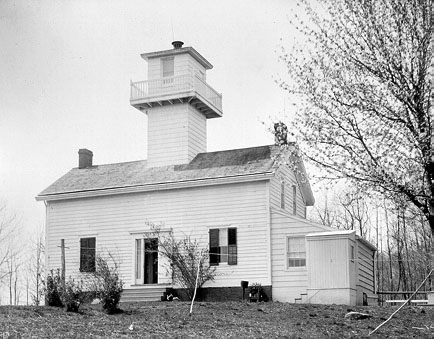
The New Dorp Lighthouse is a decommissioned lighthouse located in the New Dorp section of Staten Island, New York City. Funds for the lighthouse were approved by United States Congress on August 31, 1852 and the structure was completed in 1856. The lighthouse, built to serve as a rear range light to mark Swash Channel, was built by Richard Carlow, who also built the similar Chapel Hill and Point Comfort Range Lights in New Jersey around the same time. Ships sailing through Swash Channel were instructed to bring the New Dorp range light “in one” and steer towards the lights until the Chapel Hill Light came into view, which would then mark the channel past West Bank.
46. Elizabeth H. Berger Plaza

Elizabeth H. Berger Plaza is a public park in the Financial District of Manhattan, New York City. formed by the triangular junction of Trinity Place, Greenwich Street and Edgar Street. It faces the Manhattan exit ramp from the Brooklyn–Battery Tunnel. Formerly known as the Edgar Street Greenstreet, this park honors civic advocate Elizabeth H. Berger (1960-2013). In her role as president of the Downtown Alliance, she advocated for the fusion of two traffic triangles at this location into an expanded park. The park is located on the site of a former neighborhood known as Little Syria, a bustling immigrant community displaced by the construction of the tunnel in 1953.
47. Skyscraper Museum

The Skyscraper Museum is an architecture museum located in Battery Park City, Manhattan, New York City and founded in 1996. As the name suggests, the museum focuses on high-rise buildings as "products of technology, objects of design, sites of construction, investments in real estate, and places of work and residence." The Skyscraper Museum also celebrates the architectural heritage of New York and the forces and people who created New York's skyline. Before moving to the current and permanent location in Battery Park City in 2004, the museum was a nomadic institution, holding pop-up exhibitions in four temporary donated spaces around Lower Manhattan since 1996.
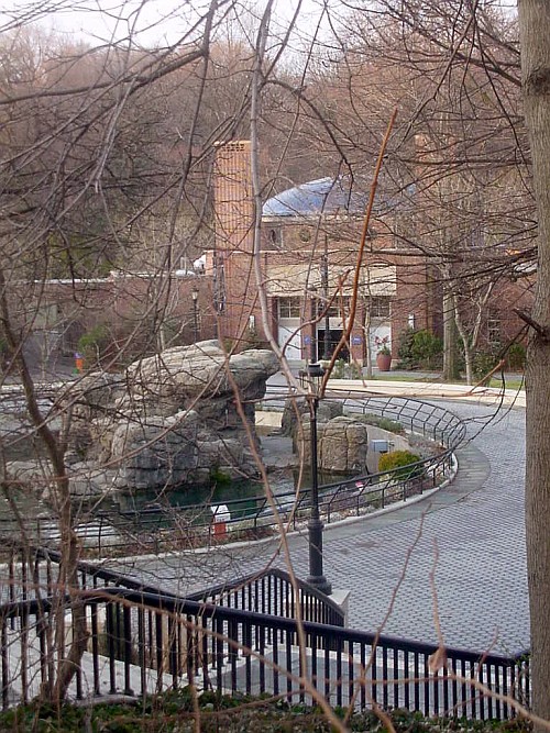
48. New York Aquarium

The New York Aquarium is the oldest continually operating aquarium in the United States, located on the Riegelmann Boardwalk in Coney Island, Brooklyn, New York City. It was founded at Castle Garden in Battery Park, Manhattan, in 1896, and moved to Coney Island in 1957. The aquarium is operated by the Wildlife Conservation Society (WCS) as part of its integrated system of four zoos and one aquarium, most notably the Bronx Zoo. It is accredited by the Association of Zoos and Aquariums (AZA). As part of WCS, the aquarium's mission is to save wildlife and wild places worldwide through science, conservation action, education, and inspiring people to value nature.
49. Chelsea Park

Chelsea Park is a park in the Chelsea neighborhood of Manhattan, New York City, that dates back to 1910. The park has sports fields, basketball and handball courts, a children's playground and space for sitting. The surface is mostly tarmac or artificial turf, with pits for the plane trees and some plots with annual flower plantings. There is a statue to a World War I soldier, the "Doughboy Statue", erected in 1921. The process of approval, funding and clearing the tenements that occupied the site was protracted. The park has since been upgraded several times by the Works Progress Administration and the New York City Department of Parks and Recreation.
50. The Noguchi Museum
The Noguchi Museum, chartered as The Isamu Noguchi Foundation and Garden Museum, is a museum and sculpture garden in the Long Island City section of Queens, New York City, designed and created by the Japanese American sculptor Isamu Noguchi (1904–1988). Opening on a limited basis to the public in 1985, the museum and foundation were intended to preserve and display Noguchi's sculptures, architectural models, stage designs, drawings, and furniture designs. The two-story, 24,000 square feet (2,200 m2) museum and sculpture garden, one block from the Socrates Sculpture Park, underwent major renovations in 2004 allowing the museum to stay open year-round.
51. Cherry Hill Fountain

Cherry Hill Fountain is a water fountain in New York City's Central Park. It is located just to the west of Bethesda Fountain, enclosed in a circular plaza in Cherry Hill. Designed by Jacob Wrey Mould and dedicated in the 1860s, the ornamental structure was originally designed as a watering trough for horses during the 19th century. The fountain consists of a granite dome and sculpted bluestone basin, measuring 20 feet (6.1 m) in diameter and inset with Minton tiles. The fountain is topped by a finial with eight frosted round glass lamps and a golden spire. Only the stone base was completed as part of the original design; the finial was added in 1981.
Wikipedia: Cherry Hill Fountain (EN), Website, Website Alternate
52. Henry Hudson Monument

The Riverdale–Spuyten Duyvil–Kingsbridge Memorial Bell Tower or Riverdale Monument is a memorial tower in Bell Tower Park located in the Riverdale section of the Bronx. It was completed on September 17, 1930 to commemorate World War I veterans from the neighborhoods of Riverdale, Spuyten Duyvil, and Kingsbridge. The plaque attached to the memorial lists the names of those Riverdale, Spuyten Duyvil, and Kingsbridge residence who served in World War I. In 1936, it was moved 700 feet south to make room for the Henry Hudson Parkway which it now stands next to. It was listed on the National Register of Historic Places on January 3, 2012.
53. Kingsland Homestead

Kingsland Homestead is an 18th-century house located in Flushing, Queens, New York City. It is the home of the remains of The Weeping Beech, a landmark weeping beech tree, believed to have been planted in 1847. The homestead is also close to the 17th-century Bowne House, the location of the first Quaker meeting place in New Amsterdam. The homestead is operated by the Queens Historical Society, whose quarters are inside; the homestead is open to the public as a museum. The Kingsland Homestead is a member of the Historic House Trust, and is both a New York City designated landmark and a National Register of Historic Places listing.
54. Unisphere

The Unisphere is a spherical stainless steel representation of the Earth in Flushing Meadows–Corona Park in the borough of Queens in New York City, New York, United States. The globe was designed by Gilmore D. Clarke as part of his plan for the 1964 New York World's Fair. Commissioned to celebrate the beginning of the space age, the Unisphere was conceived and constructed as the theme symbol of the World's Fair. The theme of the World's Fair was "Peace Through Understanding", and the Unisphere represented the theme of global interdependence, being dedicated to "Man's Achievements on a Shrinking Globe in an Expanding Universe".
55. First Presbyterian Church

The First Presbyterian Church, known as "Old First", is a church located at 48 Fifth Avenue between West 11th and 12th Streets in the Greenwich Village neighborhood of Manhattan, New York City. It was built in 1844–1846, and designed by Joseph C. Wells in the Gothic Revival style. The south transept of the building was added in 1893–1894, and was designed by the firm of McKim, Mead & White. The church complex, which includes a parish house – now referred to as the "South Wing" – on West 11th Street and a church house on West 12th Street designed by Edgar Tafel, is located within the Greenwich Village Historic District.
56. Eternal Light Flagstaff

The Eternal Light Flagstaff is a memorial monument located in Madison Square Park in Manhattan, New York City which was dedicated on Armistice Day, November 11, 1923, and commemorates the return to the United States of members of the United States armed forces who fought in World War I, who were officially received by the city on that site in 1918. It was designed by architect Thomas Hastings of Carrère and Hastings, and consists of a flagstaff and a sculpture by Paul Wayland Bartlett. The memorial was commissioned by department store magnate Rodman Wanamaker and cost $25,000 to construct. It was completed in 1924.
57. Candler Building

The Candler Building is a skyscraper at the southern end of Times Square in the Midtown Manhattan neighborhood of New York City. Located at 220 West 42nd Street, with a secondary address of 221 West 41st Street, the 24-story building was designed by the firm of Willauer, Shape and Bready in the Spanish Renaissance style. It was constructed between 1912 and 1913 for Coca-Cola Company owner Asa Griggs Candler. The Candler Building was one of the last skyscrapers built in New York City before the 1916 Zoning Resolution, which required setbacks. It is listed on the National Register of Historic Places (NRHP).
Wikipedia: Candler Building (New York City) (EN), Heritage Website
58. Alley Pond Park

Alley Pond Park is the second-largest public park in Queens, New York City, occupying 655.3 acres (265.2 ha). The park is bordered to the east by Douglaston, to the west by Bayside, to the north by Little Neck Bay, and to the south by Union Turnpike. The Cross Island Parkway travels north-south through the park, while the Long Island Expressway and Grand Central Parkway travel east-west through the park. The park primarily consists of woodlands south of the Long Island Expressway and meadowlands north of the expressway. It is run and operated by the New York City Department of Parks and Recreation.
59. Calvert Vaux Park
Calvert Vaux Park is an 85.53-acre (34.61 ha) public park in Gravesend, Brooklyn, in New York City. Created in 1934, it is composed of several disconnected sections along the Belt Parkway between Bay 44th and Bay 49th Streets. The peninsula upon which the park is located faces southwest into Gravesend Bay, immediately north of the Coney Island Creek. The park was expanded in the 1960s by waste from the construction of the Verrazzano-Narrows Bridge, and was renamed after architect Calvert Vaux in 1998. It is operated by the New York City Department of Parks and Recreation, also known as NYC Parks.
60. Frederick Douglass Memorial

The Frederick Douglass Memorial is a memorial commemorating Frederick Douglass, installed at the northwest corner of New York City's Central Park, in the U.S. state of New York. The memorial includes an 8-foot bronze sculpture depicting Douglass by Gabriel Koren and a large circle and fountain designed by Algernon Miller. Additionally, Quennell Rothschild & Partners is credited as the memorial's architecture, and Polich-Tallix served as the foundry. The memorial was dedicated on September 20, 2011, and was funded by the Percent for Art program and the, New York City Department of Cultural Affairs.
Wikipedia: Frederick Douglass Memorial (EN), Website, Website Alternate
61. King Manor Museum

King Manor, also known as the Rufus King House, is a historic house at 150th Street and Jamaica Avenue in Jamaica, Queens, New York City. The two-story house is the main structure in Rufus King Park, an 11.5-acre (4.7 ha) public park that preserves part of the former estate of Rufus King, a U.S. Founding Father. Built c. 1730 and expanded in 1755 and the 1800s, the house is designed with elements of the Federal, Georgian, and Greek Revival styles. The house is designated as a National Historic Landmark, and the house, its interior spaces, and the park are all New York City designated landmarks.
62. Prospect Park Zoo
The Prospect Park Zoo is a 12-acre (4.9 ha) zoo located off Flatbush Avenue on the eastern side of Prospect Park, Brooklyn, New York City. As of 2016, the zoo houses 864 animals representing about 176 species, and as of 2007, it averages 300,000 visitors annually. The Prospect Park Zoo is operated by the Wildlife Conservation Society (WCS). In conjunction with the Prospect Park Zoo's operations, the WCS offers children's educational programs, is engaged in restoration of endangered species populations, runs a wildlife theater, and reaches out to the local community through volunteer programs.
63. General Grant National Memorial

Grant's Tomb, officially the General Grant National Memorial, is the final resting place of Ulysses S. Grant, the 18th president of the United States, and of his wife Julia. It is a classical domed mausoleum in the Morningside Heights neighborhood of Upper Manhattan in New York City, New York, United States. The structure is in the middle of Riverside Drive at 122nd Street, adjacent to Riverside Park. In addition to being a national memorial since 1958, Grant's Tomb is listed on the National Register of Historic Places, and its facade and interior are New York City designated landmarks.
64. Independence Flagstaff

Independence Flagstaff, also known as the Charles F. Murphy Memorial Flagpole, is an outdoor memorial by sculptor Anthony de Francisci, located in Union Square Park in Manhattan, New York, which commemorates the 150th anniversary of the signing of the United States Declaration of Independence. The memorial was cast in 1926 and dedicated on July 4, 1930. It was made of steel, with copper sheathing, and is set on a granite pedestal which includes bronze bas-reliefs and plaques. The monument is in axial alignment with Henry Kirke Brown's statues of George Washington and Abraham Lincoln.
65. James Stranahan

J.S.T. Stranahan is a bronze statue in Brooklyn's Prospect Park in New York City. Designed by Frederick William MacMonnies and erected in 1891 near the park's entrance at Grand Army Plaza, it honors James S. T. Stranahan, a businessman from Brooklyn who served on the city's park commission and was instrumental in Prospect Park's creation. The statue is considered one of MacMonnies' finest works and was praised for its realism. An inscription on the pedestal of the statue includes the Latin phrase LECTOR SI MONUMENTUM REQUIRIS CIRCUMSPICE which also marks the tomb of Christopher Wren.
66. La Plaza Cultural

La Plaza Cultural de Armando Perez is a community garden and public green space in the East Village neighborhood of Manhattan, New York City. Serving as a community garden, park, playground, wildlife refuge, urban farm, community composting site, and performance venue, La Plaza Cultural is also utilized by local day-care centers, after-school programs and a growing number of parents with small children. The garden has been known to grow a number of various edible plants including fruits, vegetable, and herbs. The lot is approximately 0.64 acres and consists of at least 11 members.
67. David H. Koch Theater

The David H. Koch Theater is a theater for ballet, modern and other forms of dance, part of the Lincoln Center, at the intersection of Columbus Avenue and 63rd Street in the Lincoln Square neighborhood of Manhattan in New York City. Originally named the New York State Theater, the venue has been home to the New York City Ballet since its opening in 1964, the secondary venue for the American Ballet Theatre in the fall, and served as home to the New York City Opera from 1964 to 2011. The theater occupies the south side of the main plaza of Lincoln Center, opposite David Geffen Hall.
68. Morris-Jumel Mansion

The Morris–Jumel Mansion is an 18th-century historic house museum in the Washington Heights neighborhood of Upper Manhattan in New York City. It is the oldest extant house in Manhattan, having been built in 1765 by British military officer Roger Morris, and was also home to the family of socialite Eliza Jumel in the 19th century. The New York City government has owned the house since 1903. The house's facade and interior are New York City designated landmarks, and the building is a National Historic Landmark and a contributing property to the Jumel Terrace Historic District.
69. Grace Church

Grace Church is a historic parish church in Manhattan, New York City which is part of the Episcopal Diocese of New York. The church is located at 800–804 Broadway, at the corner of East 10th Street, where Broadway bends to the south-southeast, bringing it in alignment with the avenues in Manhattan's grid. Grace Church School and the church houses—which are now used by the school—are located to the east at 86–98 Fourth Avenue between East 10th and 12th Streets. In 2021, it reported 1,038 members, average attendance of 212, and $1,034,712 in plate and pledge income.
70. Federal Hall National Memorial

Federal Hall is a memorial and historic site at 26 Wall Street in the Financial District of Manhattan in New York City. The current Greek Revival–style building, completed in 1842 as the Custom House, is owned by the United States federal government and operated by the National Park Service as a national memorial called the Federal Hall National Memorial. The memorial is named for an earlier Federal style building on this same site, completed in 1703 as City Hall, which the government of the newly independent United States used as its capital building during the 1780s.
71. Brooklyn Botanic Garden

Brooklyn Botanic Garden (BBG) is a botanical garden in the borough of Brooklyn in New York City. The botanical garden occupies 52 acres (21 ha) in central Brooklyn, close to Mount Prospect Park, Prospect Park, and the Brooklyn Museum. Designed by the Olmsted Brothers, BBG holds over 14,000 taxa of plants and has over 800,000 visitors each year. It includes a number of specialty gardens, plant collections, and structures. BBG hosts numerous educational programs, plant-science and conservation, and community horticulture initiatives, in addition to a herbarium collection.
72. Metropolitan Baptist Church

The Metropolitan Baptist Church, located at 151 West 128th Street on the corner of Adam Clayton Powell Jr. Boulevard in the Harlem neighborhood of Manhattan, New York City, was originally built in two sections for the New York Presbyterian Church, which moved to the new building from 167 West 111th Street. The chapel and lecture room were built in 1884-85 and were designed by John Rochester Thomas, while the main sanctuary was constructed in 1889-90 and was designed by Richard R. Davis, perhaps following Thomas's unused design. A planned corner tower was never built.
73. Weeksville Heritage Center

The Weeksville Heritage Center is a historic site on Buffalo Avenue between St. Marks Avenue and Bergen Street in Crown Heights, Brooklyn, New York City. It is dedicated to the preservation of Weeksville, one of America's first free black communities during the 19th century. Within this community, the residents established schools, churches and benevolent associations and were active in the abolitionist movement. Weeksville is a historic settlement of national significance and one of the few remaining historical sites of pre-Civil War African-American communities.
74. Quarters A

Quarters A, also known as the Commandant's House, is a historic house on Evans Street in the Vinegar Hill neighborhood of Brooklyn, New York City. Built beginning in 1805, with a number of later alterations, it remains a prominent example of Federal architecture in New York City. It was designated a National Historic Landmark in 1974 for its association with Matthew C. Perry, commandant of the adjacent Brooklyn Navy Yard 1841–1843, whose opening of Japan to the West in 1854 revolutionized trade and international affairs. The building is now privately owned.
Wikipedia: Quarters A, Brooklyn Navy Yard (EN), Heritage Website
75. Circle in the Square Theatre

The Circle in the Square Theatre is a Broadway theater at 235 West 50th Street, within the basement of Paramount Plaza, in the Midtown Manhattan neighborhood of New York City. The current Broadway theater, completed in 1972, is the successor of an off-Broadway theater of the same name, co-founded around 1950 by a group that included Theodore Mann and José Quintero. The Broadway venue was designed by Allen Sayles; it originally contained 650 seats and uses a thrust stage that extends into the audience on three sides. The theater had 751 seats as of 2022.
76. Unitarian Church of All Souls

The Unitarian Church of All Souls at 1157 Lexington Avenue at East 80th Street in the Upper East Side of Manhattan, New York City was built in 1932 and was designed by Hobart Upjohn – Richard Upjohn's grandson – in the Neo-colonial style with a Regency-influenced brick base. It is the congregation's fourth sanctuary. The congregation, dating back to 1819, was the first Unitarian Universalist congregation in the city. It has provided a pulpit for some of the movement's leading theologians and has also recorded many eminent persons in its membership.
77. Queens Museum
The Queens Museum, formerly the Queens Museum of Art, is an art museum and educational center located in Flushing Meadows–Corona Park in the borough of Queens in New York City, United States. The museum was founded in 1972, and has among its permanent exhibitions, the Panorama of the City of New York, a room-sized scale model of the five boroughs originally built for the 1964 New York World's Fair, and repeatedly updated since then. It also has a large archive of artifacts from both the 1939 and 1964 World's Fairs, a selection of which is on display.
78. Thomas Jefferson Park

Thomas Jefferson Park is a 15.52-acre (6.28 ha) public park in the East Harlem neighborhood of Manhattan in New York City. The park is on First Avenue between 111th and 114th Streets. It contains a playground as well as facilities for baseball, basketball, football, handball, running, skating, and soccer. The Thomas Jefferson Play Center within the park consists of a recreation center and a pool. The park and play center, named for former U.S. president Thomas Jefferson, are maintained by the New York City Department of Parks and Recreation.
79. Central Synagogue

The Central Synagogue is a Reform Jewish congregation and synagogue at 652 Lexington Avenue, at the corner of East 55th Street in the Midtown Manhattan neighborhood of New York City. Built from 1870 to 1872 and designed by Henry Fernbach in the Moorish Revival style, the synagogue was influenced by Budapest's Dohány Street Synagogue. It has been continuously used by a congregation for longer than any other in New York state, except Congregation Berith Sholom in Troy, and is among the oldest existing synagogue buildings in the United States.
80. Prospect Park South

Prospect Park South is a small neighborhood in Flatbush, Brooklyn, New York City, located south of Prospect Park. It is included within the Prospect Park South Historic District, which was designated by the New York City Landmarks Preservation Commission in 1979 and listed on the National Register of Historic Places in 1983. The historic district is bounded by Church Avenue to the north, the BMT Brighton Line of the New York City Subway to the east, Beverley Road to the south, and between Stratford Road and Coney Island Avenue to the west.
81. Trinity Lutheran Church

Trinity Lutheran Church is a historic Lutheran church at 31-18 37th Street in Astoria, Queens, New York. It was designed by John William Cresswell Corbusier and overseen by architect George W. Conable (1866–1933). It was built in 1926 and is a one-story Collegiate Gothic style building. It is constructed of brick faced with coursed rubble aplite trimmed in cast stone. The front elevation features a recessed entry with a large window above, framed by two spires with ornate turrets. The interior is in a Gothic plan of nave and transepts.
82. Charging Bull
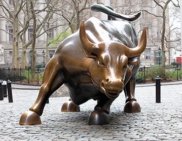
Charging Bull, sometimes referred to as the Bull of Wall Street or the Bowling Green Bull, is a bronze sculpture that stands on Broadway just north of Bowling Green in the Financial District of Manhattan in New York City. The 7,100-pound (3,200 kg) bronze sculpture, standing 11 feet (3.4 m) tall and measuring 16 feet (4.9 m) long, depicts a bull, the symbol of financial optimism and prosperity. Charging Bull is a popular tourist destination that draws thousands of people a day, symbolizing Wall Street and the Financial District.
83. Metropolitan Opera House

The Metropolitan Opera House is an opera house located on Broadway at Lincoln Square on the Upper West Side of Manhattan in New York City. Part of Lincoln Center, the theater was designed by Wallace K. Harrison. It opened in 1966, replacing the original 1883 Metropolitan Opera House at Broadway and 39th Street. With a seating capacity of approximately 3,850, the house is the largest repertory opera house in the world. Home to the Metropolitan Opera Company, the facility also hosts the American Ballet Theatre in the summer months.
Wikipedia: Metropolitan Opera House (Lincoln Center) (EN), Website
84. The Queen Elizabeth II September 11th Garden

The Queen Elizabeth II September 11th Garden is located in Hanover Square in the Financial District of Lower Manhattan, New York City. It commemorates the Commonwealth of Nations member states' victims of the September 11, 2001 attacks on the World Trade Center. It was officially opened by Queen Elizabeth II on July 6, 2010, in a ceremony alongside her husband Prince Philip, Duke of Edinburgh, then-Mayor of New York City Michael Bloomberg, then-Governor of New York David Paterson, and then-Governor of New Jersey Chris Christie.
Wikipedia: Queen Elizabeth II September 11th Garden (EN), Website
85. Museum of American Finance
The Museum of American Finance is the United States's only independent public museum dedicated to preserving, exhibiting and teaching about American finance and financial history. Located in the Financial District in Manhattan, New York City, it is an affiliate of the Smithsonian Institution. It is a tax-exempt 501(c)(3) organization chartered by the Board of Regents of the New York State Department of Education. With education at the core of its mission, it is an active national-level advocate on behalf of financial literacy.
86. Intrepid Museum

The Intrepid Museum is an American military and maritime history museum in New York City. It is located at Pier 86 at 46th Street, along the Hudson River, in the Hell's Kitchen neighborhood on the West Side of Manhattan. The museum is mostly composed of exhibits, aircraft, and spacecraft aboard the museum ship USS Intrepid, a World War II–era aircraft carrier, as well as the cruise missile submarine USS Growler and Pier 86. The Intrepid Museum Foundation, a 501(c)(3) organization established in 1979, operates the museum.
87. Canarsie Pier

Canarsie is a mostly residential neighborhood in the southeastern portion of Brooklyn, New York City. Canarsie is bordered on the east by Fresh Creek Basin, East 108th Street, and Louisiana Avenue; on the north by Linden Boulevard; on the west by Ralph Avenue; on the southwest by Paerdegat Basin; and on the south by Jamaica Bay. It is adjacent to the neighborhoods of East Flatbush to the west, Flatlands and Bergen Beach to the southwest, Starrett City to the east, East New York to the northeast, and Brownsville to the north.
88. Hayden Planetarium

The Rose Center for Earth and Space is a part of the American Museum of Natural History in New York City. The Center's complete name is The Frederick Phineas and Sandra Priest Rose Center for Earth and Space. The main entrance is located on the northern side of the museum on 81st Street near Central Park West in Manhattan's Upper West Side. Completed in 2000, it includes the new Hayden Planetarium, the original of which was opened in 1935 and closed in 1997. Neil deGrasse Tyson is its first and, to date, only director.
89. Broadhurst Theatre

The Broadhurst Theatre is a Broadway theater at 235 West 44th Street in the Theater District of Midtown Manhattan in New York City. Opened in 1917, the theater was designed by Herbert J. Krapp and was built for the Shubert brothers. The Broadhurst Theatre is named for British-American theatrical producer George Broadhurst, who leased the theater before its opening. It has 1,218 seats across two levels and is operated by The Shubert Organization. Both the facade and the auditorium interior are New York City landmarks.
90. Booth Theatre

The Booth Theatre is a Broadway theater at 222 West 45th Street in the Theater District of Midtown Manhattan in New York City. Opened in 1913, the theater was designed by Henry Beaumont Herts in the Italian Renaissance style and was built for the Shubert brothers. The venue was originally operated by Winthrop Ames, who named it for 19th-century American actor Edwin Booth. It has 800 seats across two levels and is operated by The Shubert Organization. The facade and parts of the interior are New York City landmarks.
91. Most Precious Blood Church

The Church of the Most Precious Blood is a Roman Catholic parish located in New York City. The parish is under the authority of the Archdiocese of New York, and is the National Shrine Church of San Gennaro. Located at 113 Baxter Street with an additional entrance on Mulberry Street, the Church of the Most Precious Blood is part of Manhattan's Little Italy neighborhood. The Most Precious Blood parished merged with Old St. Patrick's Cathedral parish, and the two churches share priests and administrative staff.
Wikipedia: Church of the Most Precious Blood (Manhattan) (EN)
92. Queens Theater

Queens Theatre, formerly Queens Theatre in the Park and before that Queens Playhouse, is an American professional theatre, located in Flushing Meadows–Corona Park, Queens, New York City, New York. Artistic and Executive Directors have included Joseph S. Kutrzeba, founder and producer; Robert Moss, Sue Lawless, Jeffrey Rosenstock and Ray Cullom, formerly Managing Director of Long Wharf Theatre in New Haven, CT, and currently, Taryn Sacramone, former Executive Director of Astoria Performing Arts Center.
93. Church of Saint Mary the Virgin

The Church of Saint Mary the Virgin is an Episcopal Anglo-Catholic church in Midtown Manhattan, New York City, which is part of the Episcopal Diocese of New York of the Episcopal Church in the United States of America. The church complex is located in the heart of Times Square at 133-145 West 46th Street, with other buildings of the complex at 136-144 West 47th Street, between Sixth and Seventh Avenues. It is colloquially known as "Smoky Mary's" because of the amount of incense used in the services.
Wikipedia: Church of St. Mary the Virgin (Manhattan) (EN), Website
94. Calvary Church

Calvary Church is an Episcopal church located at 277 Park Avenue South on the corner of East 21st Street in the Gramercy Park neighborhood of Manhattan, New York City, on the border of the Flatiron District. It was designed by James Renwick Jr., the architect who designed St. Patrick's Cathedral and Grace Church, and was completed in 1848. The church complex is located within the Gramercy Park Historic District and Extension. It is one of the two sanctuaries of the Calvary-St. George's Parish.
95. Lucy Drexel Dahlgren House

The Lucy Drexel Dahlgren House is a historic home located at 15 East 96th Street between Fifth and Madison Avenues in Manhattan, New York City. It is on the border between the Carnegie Hill, Upper East Side, and East Harlem neighborhoods on the Upper East Side, within the Upper East Side Historic District. A private house used at one time as a convent, it was built in 1915–16 for Lucy Wharton Drexel Dahlgren. It is a New York City Landmark and is on the National Register of Historic Places.
Wikipedia: Lucy Drexel Dahlgren House (EN), Heritage Website
96. West End Collegiate Church

The West End Collegiate Church is a church on West End Avenue at 77th Street on Manhattan's Upper West Side. It is part of The Collegiate Reformed Protestant Dutch Church in the City of New York, the oldest Protestant church with a continuing organization in America. The Collegiate Church of New York is dually affiliated with the United Church of Christ (UCC) and the Reformed Church in America (RCA). The West End Collegiate Church is listed on the U.S. National Register of Historic Places.
97. Maryland 400 Monument

The Maryland 400 were members of the 1st Maryland Regiment who repeatedly charged a numerically superior British force during the Battle of Long Island during the Revolutionary War, sustaining heavy casualties, but allowing General Washington to successfully evacuate the bulk of his troops to Manhattan. This action is commemorated in Maryland's nickname, the "Old Line State." A monument in Brooklyn and multiple plaques were put up in the memory of this regiment and the fallen soldiers.
98. Lefferts Historic House

The Lefferts Historic House is located within Prospect Park in Brooklyn, New York City. Built circa 1783, it is the former home of enslaved persons and the family of Continental Army Lieutenant Pieter Lefferts. It currently operates as a museum of the Leffertses' family life in Kings County. The museum is part of the Historic House Trust, owned by the New York City Department of Parks and Recreation and operated by the Prospect Park Alliance. It is a New York City designated landmark.
99. MoMA PS1

MoMA PS1 is a contemporary art institution located in Court Square in the Long Island City neighborhood in the borough of Queens, New York City, United States. In addition to its exhibitions, the institution organizes the Sunday Sessions performance series, the Warm Up summer music series, and the Young Architects Program with the Museum of Modern Art. MoMA PS1 has been affiliated with the Museum of Modern Art since January 2000 and, as of 2013, attracts about 200,000 visitors a year.
100. Harriet Tubman Memorial

The Harriet Tubman Memorial, also known as Swing Low, located in Manhattan in New York City, honors the life of abolitionist Harriet Tubman. The intersection at which it stands was previously a barren traffic island, and is now known as "Harriet Tubman Triangle". As part of its redevelopment, the traffic island was landscaped with plants native to New York and to Tubman's home state of Maryland, representing the land which she and her Underground Railroad passengers travelled across.
Share
Disclaimer Please be aware of your surroundings and do not enter private property. We are not liable for any damages that occur during the tours.