30 Sights in Minneapolis, United States (with Map and Images)
Legend
Explore interesting sights in Minneapolis, United States. Click on a marker on the map to view details about it. Underneath is an overview of the sights with images. A total of 30 sights are available in Minneapolis, United States.
Sightseeing Tours in Minneapolis1. Third Avenue Bridge
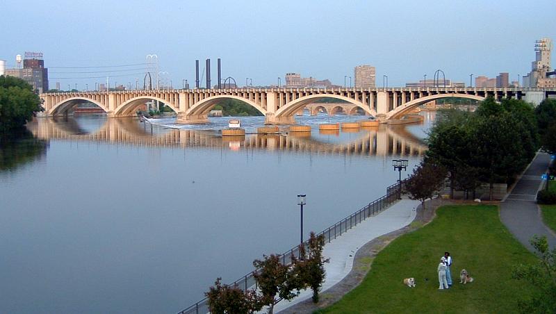
The Third Avenue Bridge is a landmark structure of the city of Minneapolis, Minnesota, United States, originally known as the St. Anthony Falls Bridge. It carries road traffic across the Mississippi River and upper fringes of Saint Anthony Falls. The multi-arched bridge meets with Third Avenue in downtown Minneapolis at its south end, but curves as it crosses the river, and connects with Central Avenue on its north end. The shallow "S" curve in the bridge was built to avoid fractures in the limestone bedrock that supports the bridge piers. The road is also designated Minnesota State Highway 65. Construction began in 1914, and it opened four years later in 1918. The bridge, which uses Melan arches of an open spandrel design, has been modified since that time. The 2,223-foot crossing was designed by city engineer Frederick W. Cappelen, who also created plans for other similar bridges in Minneapolis such as the Franklin Avenue Bridge. It cost US$862,254.00 at the time of construction.
2. Kenwood Park Water Tower

The Kenwood Park Water Tower is an octagonal brick and stone water tower in the Kenwood neighborhood of Minneapolis, Minnesota, United States. It was built in 1910 and designed by Frederick William Cappelen, the city of Minneapolis engineer at the time. The tower is 110 feet tall, making it the tallest structure in Kenwood. The tower has not been used to store water since 1954. The tower was built to alleviate water pressure and storage problems in the Lowry Hill area. Although the tower is not the work of a master architect or representative of a specific architectural style, its design is distinctive. It is ornamented with projecting ribs, narrow rectangular windows, and Lombard bands, suggesting a medieval fortress. The tower serves as a distinct visual focus within the neighborhood.
3. The Museum of Russian Art

The Museum of Russian Art (TMORA), a nonprofit museum in Minneapolis, Minnesota, United States, is the only major institution in North America devoted entirely to Russian art and culture from the entire scope of Russia's history. The Museum was founded by prominent art collectors Raymond and Susan Johnson, owners of the largest collection of Russian Realist paintings outside the borders of the former Soviet Union. TMORA was incorporated as a nonprofit in 2002 and opened at its present location in 2005. The museum shows 8-10 exhibitions per year, and hosts over 50 annual events ranging from notable lecturers to classical concerts to theatrical readings. TMORA is open daily, located between Downtown Minneapolis and the Minneapolis Saint Paul Airport.
4. Interlachen Bridge

The Interlachen Bridge is a reinforced concrete arch bridge on William Berry Parkway between Bde Maka Ska and Lake Harriet in Minneapolis, Minnesota. The bridge crosses the Como-Harriet Streetcar Line, a heritage streetcar line operated by the Minnesota Streetcar Museum which follows the same right-of-way as the original Twin Cities Rapid Transit line of the same name. The bridge was designed by local builder William S. Hewett. The bridge is one of the most significant bridges in Minnesota because it is the earliest known extant concrete bridge with a documented construction date. The bridge was listed on the National Register of Historic Places on November 6, 1989, as part of the Reinforced-Concrete Highway Bridges in Minnesota MPS.
5. Pillsbury A Mill

The Pillsbury A-Mill is a former flour mill located on the east bank of the Mississippi River in Minneapolis, Minnesota. It was the world's largest flour mill for 40 years. Completed in 1881, it was owned by the Pillsbury Company and operated two of the most powerful direct-drive waterwheels ever built, each capable of generating 1,200 horsepower . In 1901 one of the turbines was replaced with a 2,500 horsepower one. Both the mill and its headrace tunnel are contributing resources to the St. Anthony Falls Historic District, which is on the National Register of Historic Places. The mill is also independently on the NRHP. The mill was named a National Historic Landmark in 1966 and has since been converted into the A-Mill Artist Lofts.
6. Southeast Franklin Avenue

The Franklin Avenue Bridge, officially the F.W. Cappelen Memorial Bridge, carries Franklin Avenue over the Mississippi River in Minneapolis, Minnesota. It was designed by Frederick William Cappelen, assisted by Kristoffer Olsen Oustad, both of whom were among four important Norwegian-American engineers working in the region at the time. The reinforced-concrete open-spandrel arched structure was completed in 1923. The bridge's overall length is 1054.7 feet, with a central span of 400 feet. It was added to the National Register of Historic Places in 1978 along with several other area bridges as part of a multiple-property submission. At the time of its completion, the bridge's central span was the longest concrete arch in the world.
7. Southeast 10th Avenue
The 10th Avenue Bridge crosses the Mississippi River near downtown Minneapolis, Minnesota and also in proximity to the University of Minnesota. The bridge historically was called the Cedar Avenue Bridge from days prior to the construction of the I-35W bridge when it connected to Cedar Ave. The bridge connects 10th Avenue Southeast, on the east side of the Mississippi River to 19th Avenue South, on the west side. The Seven Corners area of the Cedar-Riverside, Minneapolis neighborhood is at the south end of the bridge. The downstream end of the lower Saint Anthony Falls lock and dam extends under the bridge. The historic Southeast Steam Plant is also nearby.
8. Weisman Art Museum

Weisman Art Museum is an art museum at the University of Minnesota in Minneapolis, Minnesota. Founded in 1934 as University Gallery, the museum was originally housed in an upper floor of the university's Northrop Auditorium. In 1993, the museum moved to its current building, designed by the Canadian-born American architect Frank Gehry, and renamed in honor of art collector and philanthropist Frederick R. Weisman. Widely known as a "modern art museum," its 20,000+ acquisitions include large collections of traditional Korean furniture and modern American Art, including collections of work by Marsden Hartley, Alfred Maurer, Charles Biederman.
9. Foshay Tower

The Foshay Tower, now the W Minneapolis – The Foshay hotel, is a skyscraper in Minneapolis, Minnesota. Modeled after the Washington Monument, the building was completed in 1929, months before the stock market crash in October of that year. It has 32 floors and stands 447 feet (136 m) high, plus an antenna mast that extends the total height of the structure to 607 feet (185 m). The building, which was added to the National Register of Historic Places in 1978, is an example of Art Deco architecture. Its address is 821 Marquette Avenue, although it is set well back from the street and is actually closer to 9th Street than Marquette.
10. Gold Medal Park

Gold Medal Park is a 7.5-acre (3.0 ha) park in the Downtown East neighborhood of Minneapolis, Minnesota, United States. Opened in May 2007, the park was designed by landscape architect Tom Oslund and is owned by the city of Minneapolis. It takes its inspiration from the Native American mounds that are found throughout Minnesota, and its name from Gold Medal flour, a product of General Mills. It consists of a 32-foot-high (9.8 m) mound, reached by a spiral walkway rising out of a green lawn with 300 trees. The park, just east of the Guthrie Theater, provides the Mill District neighborhood with some rare green space.
11. Minnehaha Regional Park

Minnehaha Park is a city park in Minneapolis, Minnesota, United States, and home to Minnehaha Falls and the lower reaches of Minnehaha Creek. Officially named Minnehaha Regional Park, it is part of the Minneapolis Park and Recreation Board system and lies within the Mississippi National River and Recreation Area, a unit of the National Park Service. The park was designed by landscape architect Horace W.S. Cleveland in 1883 as part of the Grand Rounds Scenic Byway system, and was part of the popular steamboat Upper Mississippi River "Fashionable Tour" in the 1800s.
12. Minneapolis Institute of Art
The Minneapolis Institute of Art (Mia) is an arts museum located in Minneapolis, Minnesota, United States. Home to more than 90,000 works of art representing 5,000 years of world history, Mia is one of the largest art museums in the United States. Its permanent collection spans about 20,000 years and represents the world's diverse cultures across six continents. The museum has seven curatorial areas: Arts of Africa & the Americas; Contemporary Art; Decorative Arts, Textiles & Sculpture; Asian Art; Paintings; Photography and New Media; and Prints and Drawings.
13. Walker Art Center

The Walker Art Center is a multidisciplinary contemporary art center in the Lowry Hill neighborhood of Minneapolis, Minnesota, United States. The Walker is one of the most-visited modern and contemporary art museums in the U.S.: together with the adjacent Minneapolis Sculpture Garden and the Cowles Conservatory, it has an annual attendance of around 700,000 visitors. The museum's permanent collection includes over 13,000 modern and contemporary art pieces, including books, costumes, drawings, media works, paintings, photography, prints, and sculpture.
14. Witch's Hat Tower

The Prospect Park Water Tower, sometimes referred to as the Witch's Hat Water Tower, is a historic water tower in the Prospect Park neighborhood of Minneapolis, Minnesota, United States. It was built in 1913 on Tower Hill Park, a hilltop park established in 1906. The water tower has become the neighborhood's architectural mascot for its singular design by Frederick William Cappelen. The tower is rumored to be the inspiration for Bob Dylan's song "All Along the Watchtower," as the tower was clearly visible from Dylan's home in nearby Dinkytown.
15. Minneapolis Sculpture Garden

The Minneapolis Sculpture Garden is an 11-acre (4.5 ha) park in Minneapolis, Minnesota, in the United States. It is located near the Walker Art Center, which operates it in coordination with the Minneapolis Park and Recreation Board. It reopened June 10, 2017, after a reconstruction that resulted with the Walker and Sculpture Garden being unified as one 19-acre campus. It is one of the largest urban sculpture gardens in the country, with 40 permanent art installations and several other temporary pieces that are moved in and out periodically.
16. Riverside Plaza

Riverside Plaza is a modernist and brutalist apartment complex designed by Ralph Rapson that opened in Minneapolis, Minnesota in 1973. Situated on the edge of downtown Minneapolis in the Cedar-Riverside neighborhood, and next to both the University of Minnesota's West Bank and Augsburg University, the site contains the 39-story McKnight Building, the tallest structure outside of the city's central business district. Initially known as Cedar Square West, the complex was renamed when an investor group bought it out of receivership in 1988.
17. Guthrie Theater

The Guthrie Theater, founded in 1963, is a center for theater performance, production, education, and professional training in Minneapolis, Minnesota. The concept of the theater was born in 1959 in a series of discussions among Sir Tyrone Guthrie, Oliver Rea and Peter Zeisler. Disenchanted with Broadway, they intended to form a theater with a resident acting company, to perform classic plays in rotating repertory, while maintaining the highest professional standards.
18. Minneapolis Public Library

The Minneapolis Public Library, North Branch building is a former library in Minneapolis, Minnesota, United States. It was designed in 1893 by architect Frederick Corser. When it was opened, it was claimed to be the nation's first branch library to have open shelves so patrons could browse for books on their own, without asking librarians to retrieve them. The library set a precedent for future library development in the Minneapolis Public Library system.
19. Washburn Park Water Tower

The Washburn Park Water Tower is a landmark in the Tangle town neighborhood of south Minneapolis, Minnesota, built in 1931. It is located on top of one of the highest points of south Minneapolis. The tower is considered an unofficial "beacon" for incoming planes landing at Minneapolis-Saint Paul International Airport; however, it is not as visible to passers-by at the base of the hill due to the large homes and tall oak trees scattered on the hillside.
20. Children's Theatre Company

The Children's Theatre Company (CTC) is a regional theater established in 1965 in Minneapolis, Minnesota, specializing in plays for families, young audiences and the very young. The theater is the largest theater for multigenerational audiences in the United States and is the recipient of 2003 Tony Award for Outstanding Regional Theatre. The November 2, 2004, edition of Time magazine named the company as the top theater for children in the U.S.
21. St. Mary's Orthodox Cathedral

St. Mary's Orthodox Cathedral, also known as the Cathedral of the Protection of the Holy Virgin, is a cathedral of the Orthodox Church in America and the Diocese of the Midwest, located in Minneapolis. It is one of only two Orthodox churches in Northeast Minneapolis, and of 16 local Orthodox churches in the Twin Cities. The cathedral is dedicated to the feast of the Protection of the Virgin Mary, celebrated annually on October 1.
22. George Perry Floyd Square

George Floyd Square, officially George Perry Floyd Square, is the commemorative street name for the section of Chicago Avenue in the U.S. city of Minneapolis from East 37th Street to East 39th Street. It is named after George Floyd, a black man who was murdered there by Minneapolis police officer Derek Chauvin on May 25, 2020. The streetway and memorial site is centered at the 38th and Chicago intersection.
23. Our Lady of Lourdes

Our Lady of Lourdes Catholic Church is a Roman Catholic parish church of the Archdiocese of Saint Paul and Minneapolis located in Minneapolis, Minnesota in the United States. It was built on the east bank of the Mississippi River in today's Nicollet Island/East Bank neighborhood; it is the oldest continuously used church building in the city and is part of the St. Anthony Falls Historic District.
Wikipedia: Our Lady of Lourdes Catholic Church (Minneapolis, Minnesota) (EN), Website
24. Historic Shed

The Chicago, Milwaukee, St. Paul and Pacific Depot Freight House and Train Shed, now officially named The Depot, is a historic railroad depot in downtown Minneapolis, Minnesota, United States. At its peak, the station served 29 trains per day. Following decline, the station was closed and eventually adapted into various other uses.
25. St. Mark's Episcopal Cathedral

Saint Mark's Episcopal Cathedral in Minneapolis is one of two cathedrals in the Episcopal Church in Minnesota. The church was founded in 1858 and designated as a cathedral in 1941. Its current building dates from 1910. In 2020, it reported 764 members, 315 average attendance, and $1,021,278 in plate and pledge financial support.
Wikipedia: St. Mark's Episcopal Cathedral (Minneapolis) (EN), Website
26. Mindekirken

The Norwegian Lutheran Memorial Church of Minneapolis, better known as Mindekirken, is a Lutheran church in Minneapolis, Minnesota, United States. It is one of two American churches still using Norwegian as a primary liturgical language, the other being Minnekirken in Chicago. King Harald V of Norway is the church's patron.
Wikipedia: Norwegian Lutheran Memorial Church (Minneapolis) (EN), Website
27. Southeast Steam Plant

The Southeast Steam Plant, formerly known as the Twin City Rapid Transit Company Steam Power Plant, is a combined heat and power plant on the Mississippi River in the city of Minneapolis, Minnesota in the United States owned by the University of Minnesota.
28. Temple Israel

Temple Israel is a Reform Jewish synagogue located at 2323 Fremont Avenue South, in Minneapolis, Minnesota, in the United States. Founded in 1878, it is the oldest synagogue in Minneapolis and one of the largest Jewish congregations in the United States.
29. Queen Avenue Bridge

The Queen Avenue Bridge is a reinforced concrete single-span barrel arch bridge in Minneapolis that spans the tracks used by the Minnesota Streetcar Museum. The bridge was built in 1905 and is listed on the National Register of Historic Places.
30. Aldrich Avenue Bridge

The Midtown Greenway is a 5.7-mile (9.2 km) rail trail in Minneapolis, Minnesota that follows the path of an abandoned route of the Milwaukee Road railway. It is considered under segregated cycle facilities.
Share
Disclaimer Please be aware of your surroundings and do not enter private property. We are not liable for any damages that occur during the tours.